Portola Redwoods State Park
| Portola Redwoods State Park | |
|---|---|
|
IUCN category II (national park)
|
|

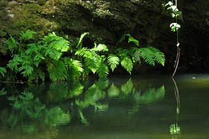
Ferns in Portola Redwoods State Park
|
|
| Location | San Mateo County, California, USA |
| Nearest city | La Honda, California, USA |
| Coordinates | 37°15′35″N 122°12′00″W / 37.25972°N 122.20000°WCoordinates: 37°15′35″N 122°12′00″W / 37.25972°N 122.20000°W |
| Area | 2,800 acres (11 km2) |
| Established | 1945 |
| Governing body | California Department of Parks and Recreation |
Portola Redwoods State Park is a California state park, located in San Mateo County. Peters Creek and Pescadero Creek meet in Portola, and are the park's primary watercourses, and feature numerous tributaries. Tip Toe Falls is a small waterfall along Fall Creek, a tributary of Pescadero Creek.
Portola Redwoods State Park contains approximately 18 miles of hiking trails in the 2,800-acre park, a small car-camping campground of about 50 campsites, four group campsites, and 6 trail sites at Slate Creek Trail Camp. Portola Redwoods State Park is also home to the site of Page shingle Mill, for which Page Mill Road is named.
The name of the state park was suggested by Aubrey Drury at a Park Commission meeting and was adopted on motion of Commissioner Leo Carrillo, a descendant of members of the Portolá expedition.
...
Wikipedia


