Porthcurno
Porthcurno
|
|
|---|---|
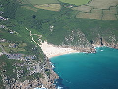
 Aerial view of Porthcurno Beach showing the Minack Theatre in the cliff face, Green Bay and the generally faint cliff-top course of the South West Coast Path. |
|
| Porthcurno shown within Cornwall | |
| OS grid reference | SW384223 |
| Unitary authority | |
| Ceremonial county | |
| Region | |
| Country | England |
| Sovereign state | United Kingdom |
| Post town | PENZANCE |
| Postcode district | TR19 |
| Dialling code | 01736 |
| Police | Devon and Cornwall |
| Fire | Cornwall |
| Ambulance | South Western |
| EU Parliament | South West England |
Porthcurno (Cornish: Porthkornow (lit: Port (or Bay) of Cornwall) is a small village covering a small valley and beach on the south coast of Cornwall, England in the United Kingdom. It is the main settlement in a civil and an ecclesiastical parish, both named St Levan, which comprise Porthcurno, diminutive St Levan itself, Trethewey and Treen.
It is centred 6.6 miles (10.6 km) west of the railway, market and resort town of Penzance and 2.5 miles (4.0 km) from Land's End, the most westerly point of the English mainland. Road access is via the north end of the valley along a long cul-de-sac with short branches off the B3283 and land traditionally associated with the village, including its beach, is on the South West Coast Path.
The village comprises houses and apartment blocks together with a few commercial premises along the access road known as "The Valley". The road curves inland past Minack Point to St. Levan's Church about 0.5 miles (0.80 km) from the village. At the southern end are:
The route is marked as two hours from Land's End or about four hours walk from Penzance for the most agile cliff-side path walkers.
A low-frequency bus service links Penzance, Lands End and nearby villages and hamlets including Newlyn, Paul, Sheffield, Lamorna, St Buryan, Treen, Trethewey, Polgigga and Sennen.
...
Wikipedia

