Port of Menteith
Port of Menteith
|
|
|---|---|
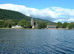
 Looking back from the Lake of Menteith to Port of Menteith, the 18th century kirk rising up from the trees and the hotel to the left |
|
| Port of Menteith shown within the Stirling council area | |
| Population | 768 (2001) |
| OS grid reference | NN581013 |
| Civil parish |
|
| Council area | |
| Lieutenancy area | |
| Country | Scotland |
| Sovereign state | United Kingdom |
| Post town | Stirling |
| Postcode district | FK8 |
| Dialling code | 01877 |
| Police | Scottish |
| Fire | Scottish |
| Ambulance | Scottish |
| EU Parliament | Scotland |
| UK Parliament | |
| Scottish Parliament | |
| Website | portofmenteith.org.uk |
Port of Menteith (Scottish Gaelic: Port Loch Innis Mo Cholmaig) is a village and civil parish in the Stirling district of Scotland, the only significant settlement on the Lake of Menteith. It was established as a burgh of barony, then named simply Port (Scottish Gaelic: Am Port), in 1457 by King James III of Scotland. It lay in the former county of Perthshire.
The village lies at the north-eastern edge of the Lake, at the junction of the A81 road with the B8034 road, which runs south, just to the west of Flanders Moss, to meet the A811 road at Arnprior. The elevation is around 25 m above sea level. The country around is generally low-lying, except to the north where the Menteith Hills rise, including Beinn Dearg (426 m), with the Trossachs and the southern Highlands beyond. The Parish includes the outlying settlements of Cobleland, Dykehead, Gartmore and Ruskie.
The parish of Port of Menteith, area 7226 hectares, had a resident population of 768 in the United Kingdom Census 2001, down from 884 in 1991.
In the summer months a ferry runs from Port of Menteith to the island of Inchmahome, site of the Historic Scotland-maintained Inchmahome Priory. The village is home to a fishing club and is the starting point for anglers on the Lake of Menteith. Nick Nairn's cookery school is based at Loch End, just south of Port of Menteith at the south-east corner of the Lake.
...
Wikipedia

