Port Erin, Isle of Man
Port Erin
|
|
|---|---|
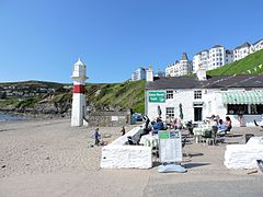
 The Cosy Nook cafe on the western end of Port Erin beach. |
|
| Port Erin shown within the Isle of Man | |
| Population | 3,530 (2011 census) |
| • Douglas | 12 miles (19 km) |
| Parish | Rushen |
| Sheading | Rushen |
| Crown dependency | Isle of Man |
| Post town | Isle Of Man |
| Postcode district | IM9 |
| Dialling code | 01624 |
| Police | Isle of Man |
| Fire | Isle of Man |
| Ambulance | Isle of Man |
| House of Keys | Rushen |
Port Erin (Manx: Purt Çhiarn, meaning lord's port) is a seaside village in the south of the Isle of Man.
The name means either iron port or Lord's port. The "Lord" may possibly refer to the parish of the Holy Trinity (Kirk Christ Rushen). Another possibility is that the name is derived from sheear, "westerly". The outer breakwater, visible at low tide only, was an abandoned project constructed in 1863 using the Port Erin Breakwater Railway and saw the first steam locomotive used on the island; a severe storm of 1884 later destroyed the breakwater and it was never rebuilt. Today, a marker buoy shows the extent of the breakwater, and the landward end is still clearly discernible. To the north-east, by the A7 road, are the earthwork remains of a motte and bailey castle known as Cronk Howe Mooar, possibly the site of a timber fortification built by Magnus Barelegs [Barefoot] c. 1100.
The steam railway station forms the western terminus of the Isle of Man Railway and sits in the centre of the village. The station has been described as "the most beautiful building in town" and is constructed of distinctive red Ruabon brick in an unusual design specifically to fit into its diagonal location between the platforms and the nearby road. The station is now a fraction of its original size, with the former bay platform and sidings now occupied by the storage yard for Bus Vannin, whilst an additional area once used for maintenance has been replaced by The Haven public house. More recent developments have seen the platform shortened and a carriage shed constructed in the yard, capable of storing eight carriages. Prior to this the rolling stock was stored in the open.
Bus services operate directly through a depot in Bridson Street in the village to the island's capital Douglas via Port St Mary, Colby, Castletown and Ballasalla using route numbers 1, 2, 11 and 12; these run about every twenty minutes at weekdays and Saturdays, with a less frequent service at weekends and after 6.00pm. Some of these services (1c and 11b) use an alternative coastal route. The route is the island's busiest, partly because it calls at the island's airport. A late evening service also operates on Friday and Saturday evenings, called the Night Owl (Hullaid Oie), which charges higher fares. There are also occasional buses to Peel (Service No. 8) via Foxdale; all these buses are within the island's transport network Bus Vannin, a government-run service which replaced the railway-operated Isle Of Man Road Services in 1976, itself a subsidiary of the railway.
...
Wikipedia

