Poquessing Creek
|
Frankford Avenue Bridge
|
|

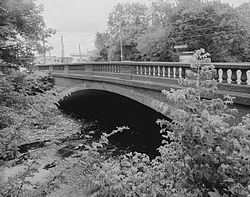
Frankford Avenue bridge over the Poquessing Creek.
|
|
| Location | Philadelphia, Pennsylvania |
|---|---|
| Coordinates | 40°03′54″N 74°58′52″W / 40.0649°N 74.9811°W |
| Built | 1904 |
| Architect | John McMenamy |
| Architectural style | Other |
| MPS | Highway Bridges Owned by the Commonwealth of Pennsylvania, Department of Transportation TR |
| NRHP Reference # | 88000850 |
| Added to NRHP | June 22, 1988 |
Poquessing Creek is a 10.3-mile-long (16.6 km) creek, a right tributary of the Delaware River, that forms part of the boundary between Bucks County and the northeast section of Philadelphia, Pennsylvania. It has been part of the boundary between Bucks and Philadelphia counties since 1682.
The creek arises in Trevose and meanders to the southeast before emptying into the Delaware River. The name Poquessing comes from the Lenape "Poetquessnink," meaning "place of the mice." The mouth of the Poquessing on the Delaware was first proposed as the site for William Penn's Philadelphia, and for many years the surrounding area was known as "Old Philadelphia."
The Poquessing watershed encompasses an area of approximately 21.5 square miles (56 km2), consisting of portions of Philadelphia, Montgomery, and Bucks counties, including the municipalities of Philadelphia, Upper Southampton, Lower Southampton, Lower Moreland, and Bensalem.
Poquessing Creek and its tributary streams have largely escaped the "channelization" process that has transformed other watersheds in the city. Other streams have had at least some significant portion of a tributary transformed into a storm sewer, as the map at this site discloses. This sewerization process had been used in the past to allow land to be leveled and filled in order to preserve the traditional, regular rectangular grid of streets and property lines so common to the city. By the 1930s this process was seen as creating many problems.
During the late 1950s, housing in new developments was built with curving through-streets that conformed to the natural topography, avoiding the need to fill or level the terrain. The Morrell Park neighborhood was the first in Philadelphia to follow this new pattern, avoiding for years any development near the stream valley of Byberry Creek, which flows through and about the neighborhood before its confluence with the Poquessing (though later years saw development much closer to the stream than originally envisioned). Channelization of the Poquessing affected only a tiny unnamed creek below Grant Avenue near Fluehr Park.
...
Wikipedia

