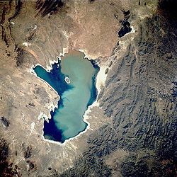
Poopó Lake
| Lake Poopó Lago Poopó |
|
|---|---|
 |
|
| Location | Altiplano |
| Coordinates | 18°33′S 67°05′W / 18.550°S 67.083°WCoordinates: 18°33′S 67°05′W / 18.550°S 67.083°W |
| Type | Endorheic salt lake |
| Primary inflows | River Desaguadero |
| Primary outflows | evaporation |
| Catchment area | 27,700 km2 (10,700 mi2) |
| Basin countries | Bolivia |
| Surface area | 1,000 km2 (390 sq mi) |
| Average depth | >1 metre (3 ft 3 in) |
| Surface elevation | 3,686 m (≈12,100 ft) |
| Settlements |
Oruro Challapata, Huari |
| Designated | 11 July 2002 |
Lake Poopó (Spanish: Lago Poopó) was a large saline lake located in a shallow depression in the Altiplano Mountains in Oruro Department, Bolivia, at an altitude of approximately 3,700 metres (12,100 ft). Because the lake was long and wide (90 by 32 kilometres (56 by 20 mi)), it made up the eastern half of the department, known as a mining region in southwest Bolivia. The permanent part of the lake body covered approximately 1,000 square kilometres (390 sq mi) and it was the second-largest lake in the country. The lake received most of its water from the Desaguadero River, which flows from Lake Titicaca at the north end of the Altiplano. Since the lake lacked any major outlet and had a mean depth of less than 3 metres (9.8 feet), the surface area differed greatly on a seasonal basis.
In 2002 the lake was designated as a site for conservation under the Ramsar Convention. By December 2015, the lake had completely dried up, leaving only a few marshy areas. Although the lake has dried up completely a couple of times in the past, it does not appear that it will recover this time. Suggested causes of the decline are the melting of the Andes glaciers and loss of their waters, because of a drought due to climate change, as well as continued diversion of water for mining and agriculture.
Archaeological investigations conducted by the San Andrés University of La Paz, Bolivia, shows the influence of the Wankarani culture in the Poopó area. Complex central urban areas, such as villages and towns, were developed that expanded into the Poopó basin during the Late Formative period, (200 BCE – 200 CE), probably in conjunction with changing patterns of agriculture. Herders and the life style of llama caravan merchants coexisted with more sedentary farmers in a harmonious system of exchange of goods and services.
...
Wikipedia
