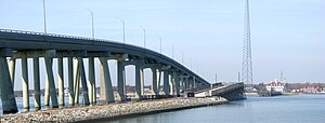
Ponquogue Bridge
| Ponquogue Bridge | |
|---|---|

The Ponquogue Bridge built in 1986 hovers over the predecessor drawbridge span, which currently serves as a fishing pier.
|
|
| Coordinates | 40°50′38″N 72°30′04″W / 40.8439°N 72.5011°WCoordinates: 40°50′38″N 72°30′04″W / 40.8439°N 72.5011°W |
| Carries | 2 lanes of County Route 32 |
| Crosses | Shinnecock Bay |
| Locale | Hampton Bays, New York |
| Maintained by | Suffolk County Department of Public Works |
| ID number | 3300520 |
| Characteristics | |
| Material | Concrete |
| Total length | 2,812 feet (857 m) |
| Width | 30 feet (9.1 m) |
| No. of spans | 29 |
| Clearance above | 55 feet (17 m) |
| History | |
| Construction end | 1986 |
| Construction cost | $14 million (1986 USD) |
| References | |
The Ponquogue Bridge is a 2,812-foot (857 m) long bridge over Shinnecock Bay in the hamlet of Hampton Bays, New York (within the town of Southampton). Maintained by the Department of Works for Suffolk County, the 29-span bridge carries two lanes of County Route 32 over the bay, connecting Hampton Bays to the eastern end of Westhampton Island. The bridge, which is made of concrete, has a 55-foot (17 m) vertical clearance above Shinnecock Bay. Constructed in 1986 at the cost of $14 million, the bridge replaced an older span over the bay, which was a 1,000-foot (300 m) long wooden drawbridge built in 1930. The former Ponquogue Bridge currently serves as a fishing pier under the current span.
In 1976, the original Ponquogue Bridge had its weight limit on the structure reduced from 15 tons to 8 tons due to the neglect condition the bridge had attained. Timbers that sustained the bridge were rotting away, which was part of making the bridge harder to maintain. Discussions between Suffolk County and the United States Coast Guard made it hard to determine the exact location of a new bridge, which was discussed since 1973. In 1977, the county applied for a new bridge to be constructed 300 feet (91 m) from the original structure, costing $6 million (1976 USD) and designed as a bulb-shaped plan. The Coast Guard found that at least 3.5 acres (1.4 ha) of wetlands would be affected by this new structure and that any proposal for a building permit would be denied. By February 1980, the county resubmitted a proposal that would reduce it to 1.5 acres (0.61 ha) and also cost $14 million (1980 USD).
The Coast Guard called in an engineering firm from New Jersey to design alternatives to the county's proposal, which would attempt to prevent damage to the wetlands. The new structure called for would have approaches 800 feet (240 m) shorter and was eventually accepted by the town board for Southampton in 1980 on a 3-2 vote. This new span, which would be 55 feet (17 m) high, was deemed ridiculous by one local, who claimed that they should choose to only replace the drawbridge, which would cost about $2 million.
...
Wikipedia
