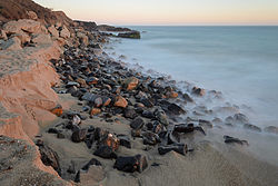
Point Mugu, California
| Point Mugu | |
|---|---|
| Unincorporated community | |

View of Pacific Ocean at Point Mugu
|
|
| Location within the state of California | |
| Coordinates: 34°5′8″N 119°3′36″W / 34.08556°N 119.06000°WCoordinates: 34°5′8″N 119°3′36″W / 34.08556°N 119.06000°W | |
| Country | United States |
| State | California |
| County | Ventura |
| Time zone | Pacific (PST) (UTC-8) |
| • Summer (DST) | PDT (UTC-7) |
| ZIP codes | 93042 |
| Area code(s) | 805 |
| GNIS feature ID | 247643 |
Point Mugu /muːˈɡuː/, California (Chumash: Muwu, "Beach" ) is a cape or promontory within Point Mugu State Park on the Pacific Coast in Ventura County, near the town of Port Hueneme and the city of Oxnard. The park has 5 miles (8 km) of shoreline and more than 70 miles (110 km) of hiking trails. The name is believed to be derived from the Chumash Indian term "Muwu", meaning "beach", which was first mentioned by Cabrillo in his journals in 1542. It is also a name applied to the nearby NAS Point Mugu, a test range facility known by various names over the years, including Pacific Missile Test Center and Naval Air Missile Test Center.
Mugu Rock is a distinctive feature of the coastal headland promontory that has been featured in many film shoots and television commercials. This igneous dike marks the western end of the Santa Monica Mountains, and the old Rancho Guadalasca boundary. The rock was formed when the roadway was cut through the near-vertical ridge of resistant volcanic rock in 1937. A route had been blasted out around the promontory in 1923-24 to complete Pacific Coast Highway between Malibu and the Oxnard Plain. This narrow path was dangerous and much of it has since eroded away.
...
Wikipedia

