Point Bridge (Pittsburgh)
| Point Bridge | |
|---|---|

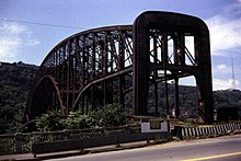
Point Bridge at Fort Pitt Blvd. in 1968
|
|
| Coordinates | 40°26′27″N 80°00′52″W / 40.4408°N 80.0145°WCoordinates: 40°26′27″N 80°00′52″W / 40.4408°N 80.0145°W |
| Crosses | Monongahela River |
| Locale | Pittsburgh, Pennsylvania |
| Official name | South Side Point Bridge |
| Characteristics | |
| Design | cantilever through truss |
| Material | steel |
| Total length | 1,120 feet (340 m) |
| Width | 38 feet (12 m) |
| Longest span | 670 feet (200 m) |
| Piers in water | 2 |
| Clearance below | 60 feet (18 m) |
| History | |
| Opened | June 20, 1927 |
| Closed | June 21, 1959 |
The Point Bridge was a steel cantilever truss bridge that spanned the Monongahela River in Pittsburgh, Pennsylvania.
In 1877, a suspension bridge called the Point Bridge was built over the Monongahela River, and is retroactively referred to as Point Bridge I by locals since being replaced by the second Point Bridge, which is sometimes called "Point Bridge II".
The bridge was constructed from 1924-1927 and was opened to traffic on 20 June 1927. It was constructed by the Fort Pitt Bridge Works of Canonsburg, Pennsylvania.
It was closer to the point than its Allegheny River counterpart, the Manchester Bridge. Its north end landed roughly where the plaza around the Point State Park fountain begins, and it's south end landed less than a tenth of a mile east of the Duquesne Incline. The south landing remains, partly shrouded by trees, between West Station Square Drive and West Carson Street. The bridge passed over an elevated span above the Point to connect the two bridges.
...
Wikipedia
