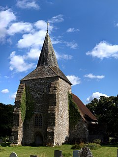
Plumpton, East Sussex
| Plumpton | |
|---|---|
 Church of St Michael, Plumpton |
|
| Plumpton shown within East Sussex | |
| Area | 9.7 km2 (3.7 sq mi) |
| Population | 1,644 (Parish-2011) |
| • Density | 450/sq mi (170/km2) |
| OS grid reference | TQ359132 |
| • London | 41 miles (66 km) N |
| District | |
| Shire county | |
| Region | |
| Country | England |
| Sovereign state | United Kingdom |
| Post town | LEWES |
| Postcode district | BN7 |
| Dialling code | 01273 |
| Police | Sussex |
| Fire | East Sussex |
| Ambulance | South East Coast |
| EU Parliament | South East England |
| UK Parliament | |
| Website | Plumpton Council |
Plumpton is a village and civil parish in the Lewes District of East Sussex, England. The village is located five miles (8 km) north-west of Lewes. The parish measures 6.5 miles in length on its north-south axis and 1 mile at its widest on the B2116 Underhill Road. The southern half of the parish lies within the South Downs National Park and the highest point is the crest of Plumpton Plain at 214m (702 feet), which is traversed by the South Downs Way. The parish includes the small village of Plumpton adjacent to the Downs and to the north the larger village of Plumpton Green where most of the community and services are based. Plumpton is probably best known for its race course and, to a lesser extent, Plumpton College, formerly Plumpton Agricultural College.
Plumpton is mentioned in the Domesday Book of 1086 as having a church and two mills, and is shown as 'Pluntune', meaning 'town or settlement where plum-trees grew'.
Plumpton Green is essentially a ribbon development immediately to the north of the railway station and is home to the school, the village shop, a church and two pubs. The main thoroughfare, Station Road, runs the length of the village, with several cul-de-sacs branching from it. The majority of the road is paved on one side only.
Chapel Road is a cul-de-sac with 24 houses. These are mostly semi-detached, with a small terrace of cottages built in 1900. Woodgate Meadow is a fairly recent development of large, detached houses on the site of a former brickyard. Westgate was built on farmland some years later (1995) incorporating mainly detached houses and also the new village hall and green.
Plumpton Lane, connecting Plumpton and Plumpton Green has, in recent years, received several small housing developments. The houses are of an attractive design, incorporating traditional red Sussex tile-hung walls.
Plumpton railway station is on the East Coastway Line and the railway crossing had the last manually operated gates in Sussex, until finally replaced by automatic gates in 2016. As of December 2010 it has an hourly service in each direction, between Eastbourne, Hastings and Ore and London Victoria. As of December 2012, the gap in this schedule around mid-day on Sundays has been eliminated, with the introduction of a full service throughout the day. Plumpton Racecourse is located between the two villages, immediately to the south of the railway. Meetings draw large crowds and on race days the population of Plumpton doubles and the rail service is supplemented with extra trains. Races are sometimes televised, bringing Plumpton to a much wider audience than it would otherwise reach.
...
Wikipedia

