Plumas National Forest
| Plumas National Forest | |
|---|---|
|
IUCN category VI (protected area with sustainable use of natural resources)
|
|

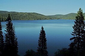
Bucks Lake in Plumas National Forest
|
|
|
Map of California
|
|
| Nearest city | Quincy, California |
| Coordinates | 40°00′01″N 120°40′05″W / 40.00028°N 120.66806°WCoordinates: 40°00′01″N 120°40′05″W / 40.00028°N 120.66806°W |
| Area | 1.1 acres (0.45 ha) |
| Established | 1907 |
| Governing body | U.S. Forest Service |
| Website | Plumas National Forest |
Plumas National Forest is a 1,146,000-acre (4,638 km2) United States National Forest located in the Sierra Nevada, in northern California.
About 85% of Plumas National Forest lies in Plumas County, but smaller portions are found in eastern Butte, northern Sierra, southern Lassen, and northeastern Yuba counties. [1] The Plumas National Forest Supervisor's office is located in Quincy, California. There are local ranger district offices in Blairsden, Oroville, and Quincy.
Plumas was established as the Plumas Forest Reserve by the General Land Office on March 27, 1905. In 1906 the forest was transferred to the U.S. Forest Service, and on March 4, 1907 it became a National Forest. On July 1, 1908 a portion of Diamond Mountain National Forest was added. The Bucks Lake Wilderness was officially designated in 1984 as a part of the National Wilderness Preservation System.
A 2002 study by the Forest Service identified 127,000 acres (51,000 ha) of the forest as old growth. The most common old-growth forest types are mixed conifer forests of:
...
Wikipedia


