Playa del Rey, Los Angeles
| Playa del Rey | |
|---|---|
| Neighborhood of Los Angeles | |
 |
|
| Location within Southern Los Angeles | |
| Coordinates: 33°57′32″N 118°26′54″W / 33.958926°N 118.448436°W | |
| Country | United States |
| State | California |
| County | Los Angeles |
| City | Los Angeles |
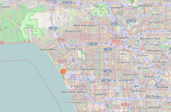
Playa del Rey (Spanish for "Beach of the King" or "King's beach") is a beachside community in the Westside of the city of Los Angeles, California. It has a ZIP code of 90293 and area codes of 310 and 424. As of 2014, the Playa del Rey (zip 90293) population was 12,129 people. Since 2000, it has had a population growth of 14.61 percent.
Playa del Rey is a coastal neighborhood and a district of City of Los Angeles. The rolling hills are the result of ancient, wind-blown, compacted sand dunes which rise up to 125 feet (38 m) above sea level, originally called and often referred to as The Del Rey Hills or "The Bluffs". These dunes run parallel to the coastline, from Playa del Rey, all the way south to Palos Verdes.
The community is bordered by the Pacific Ocean to the west, Marina del Rey and Ballona Creek to the north, Ballona Wetlands and Playa Vista to the northeast, Westchester to the east, Los Angeles International Airport and El Segundo to the south.
The northern part was originally wetlands, but the natural flooding was halted by the concrete channel which contains Ballona Creek.
In the 1870s, Playa Del Rey was the location of the first attempt at a dredged harbor in Santa Monica Bay. Under contract with the Atchison, Topeka & Santa Fe Railroad, Moye Wicks' syndicate spent $300,000 to dredge "Port Ballona Harbor", for shipping to the Orient. Within three years, winter waves brought flooding, but what remained of man's early efforts became the Playa Del Rey Lagoon, now a regional public park.
...
Wikipedia

