Playa Vista, Los Angeles
| Playa Vista | |
|---|---|
| Neighborhood of Los Angeles | |

Playa Vista from the south, with Bluff Creek in foreground
|
|
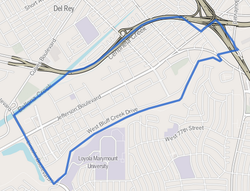
 Playa Vista neighborhood as mapped by the Los Angeles Times |
|
| Location within Western Los Angeles | |
| Coordinates: 33°58′35″N 118°25′10″W / 33.97639°N 118.41944°WCoordinates: 33°58′35″N 118°25′10″W / 33.97639°N 118.41944°W | |
| ZIP Code | 90094 |
Playa Vista is a neighborhood located in the Westside of the City of Los Angeles, California, United States, north of LAX. Prior to the development of Playa Vista, the area was the headquarters of Hughes Aircraft Company from 1941 to 1985, and was the site of the construction of the Hughes H-4 Hercules "Spruce Goose" aircraft. The area began development in 2002 as a planned community with residential, commercial, and retail components. The community has become a choice address for businesses in technology, media and entertainment and, along with Santa Monica and Venice, has become known as Silicon Beach.
The Tongva Native Americans once inhabited the location now occupied by Playa Vista. There was a Tongvan sacred burial site located here: "about 1,000 Native American remains [...] had been exhumed during construction," grave sites that were deemed sacred by the Tongva people. The remains were discovered after construction had begun. In 2008, the remains "were laid to rest and covered with white seashells during a sacred burial ceremony near the Westchester bluffs." In addition, "Playa Vista plans to complete a museum dubbed the Discovery Center to educate people about the Ballona wetlands and the Gabrieliño-Tongva tribe. It is expected to be completed at the end of [2008]."
In 1839 the land was part of Rancho La Ballona, later in 1887, it became part of the Port Ballona.
...
Wikipedia

