Plaridel, Misamis Occidental
| Plaridel | ||
|---|---|---|
| Municipality | ||

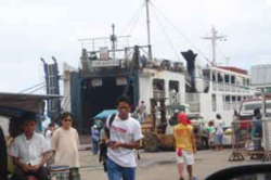
Port of Plaridel
|
||
|
||
 Map of Misamis Occidental with Plaridel highlighted |
||
| Location within the Philippines | ||
| Coordinates: 08°37′N 123°42′E / 8.617°N 123.700°ECoordinates: 08°37′N 123°42′E / 8.617°N 123.700°E | ||
| Country | Philippines | |
| Region | Northern Mindanao (Region X) | |
| Province | Misamis Occidental | |
| District | 1st district of Misamis Occidental | |
| Founded | 1907 | |
| Barangays | 33 | |
| Government | ||
| • Mayor | Engr. Diego Cacho Ty (LP) | |
| • Vice Mayor | Jim S. Tan (LP) | |
| Area | ||
| • Total | 80.00 km2 (30.89 sq mi) | |
| Population (2015 census) | ||
| • Total | 38,900 | |
| • Density | 490/km2 (1,300/sq mi) | |
| Time zone | PST (UTC+8) | |
| ZIP code | 7209 | |
| IDD : area code | +63 (0)88 | |
| Income class | 3rd municipal income class | |
| 104212000 | ||
| Electorate | 24,810 voters as of 2016 | |
| Website | www |
|
Plaridel is a third income Class municipality in the province of Misamis Occidental, Philippines. According to the 2015 census, it has a population of 38,900 people.
The Municipal Government of Plaridel, Misamis Occidental was one of the original towns of the Province of Misamis before it was divided into two (2) provinces (Oriental & Occidental) under Legislative Act. No. 3537 passed November 2, 1929.
“LANGANAN”, the local term for “delay” . A river so named because of its circuitous, winding route that traverses many kilometers. This river then was the highway by which people travelled on to reach the different settlements located along the riverbanks. Tales have it that the first Spaniard who arrived in one of the riverbank settlements asked what the name of the place was. Thinking that the Spaniard was asking for the name of the river, the settlers answered, “LANGANAN”.
The Spaniard found it hard to pronounce and instead uttered “LANGARAN” . This became the name of the place which now is the Municipality of Plaridel. Original settlers of LANGARAN were the Subanens. Farming, fishing and hunting were their means of livelihood. With their slash and burn (Kaingin) way of farming, they opened tracts of land for agricultural purposes. These tracts were later on bartered for axe heads and salt with the migrants.
The town named Langaran was changed into “Plaridel” in the year 1907, when the late Santos Palma was elected municipal President. From that period the town Langaran disintegrated bringing along a big portion of its territorial area which later on formed into a separate municipality now known as the Municipality of Sapang Dalaga and the district of Concepcion. Later on, the sitio of Daisug became a town now known as the Municipality of Lopez Jaena. During the administration of then President Manuel Acuna Roxas, Sitio Solinog now known as Calamba was created into a separate municipality.
The Municipality of Plaridel is situated at the northern portion of the Province of Misamis Occidental, Region X with coordinates 8o 55’ to 8o 65’ north latitude and 123o 65‘to 123o 75’ east longitude. It is bounded by three municipalities: Baliangao to the north, Lopez Jaena to the south and Calamba to the west. The Mindanao Sea cradles Plaridel to the east. It is composed of thirty-three (33) barangays with a total area of 8,000 hectares.
It is located between the major cities of Ozamis (67 km) and Dipolog (68 km) of Zamboanga del Norte. Plaridel can be reached from Manila or Cebu by plane through these cities. It can also be reached by boat from Manila or Cebu to Ozamis, Dipolog or even direct to Plaridel. It also has a harbor in Looc that is very well sheltered from strong winds. A passenger boat (Lite Shipping) travels to Cebu City everyday, with stops in Siquijor and Tagbilaran, Bohol. Daily boat service to Cebu is also available in the port of Ozamiz City about 67 kilometres (42 mi) to the south.
...
Wikipedia


