Plainville, Massachusetts
| Plainville, Massachusetts | ||
|---|---|---|
| Town | ||

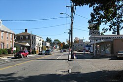
South Street
|
||
|
||
| Nickname(s): P-Ville | ||
 Location in Norfolk County in Massachusetts |
||
| Coordinates: 42°00′15″N 71°20′00″W / 42.00417°N 71.33333°WCoordinates: 42°00′15″N 71°20′00″W / 42.00417°N 71.33333°W | ||
| Country | United States | |
| State | Massachusetts | |
| County | Norfolk | |
| Settled | 1661 | |
| Incorporated | 1905 | |
| Government | ||
| • Type | Open Town Meeting | |
| Area | ||
| • Total | 11.5 sq mi (29.9 km2) | |
| • Land | 11.0 sq mi (28.6 km2) | |
| • Water | 0.5 sq mi (1.3 km2) | |
| Elevation | 250 ft (76 m) | |
| Population (2010) | ||
| • Total | 8,264 | |
| • Density | 749/sq mi (289.0/km2) | |
| Time zone | Eastern (UTC-5) | |
| • Summer (DST) | Eastern (UTC-4) | |
| ZIP code | 02762 | |
| Area code(s) | 508 / 774 | |
| FIPS code | 25-54100 | |
| GNIS feature ID | 0618327 | |
| Website | http://www.plainville.ma.us | |
Plainville is a town in Norfolk County, Massachusetts, United States. The population at the 2010 census was 8,264. Plainville is part of the Providence metropolitan area.
Originally included in a 1635 grant of land for Dedham, Massachusetts, the area was later deemed the Plantation of Wollomonuppoag and then later becoming Wrentham, Massachusetts before Plainville branched out as a separate community. Plainville became an officially recognized town in 1905, making it the third youngest town in the state, behind Millville (1916) and East Brookfield (1920).
One of the earliest documentations of Plainville being settled is from 1674, when a Wampanoag man by the name of Matchinamook petitioned and received a few acres of land at the head of the Ten Mile River, at present day Fuller's Dam. As Matchinamook was a native warrior under Wampanoag chieftain Metacomet, or more commonly known in the area as King Philip, he most likely fought during King Philip's War. In its early days, Plainville was nicknamed Slackville after Benjamin Slack, an affluent landowner at the time. After the establishment of a post office in 1856, Plainville became the town name after the abundance of geographical plains in the area. In 1905, Plainville officially separated from Wrentham and became its own town.
Along with bordering North Attleboro, Massachusetts, Plainville shares the Angle Tree Stone, a historic marker dividing the boundaries between the old Massachusetts Bay Colony and Plymouth Bay Colony. This is why the Angle Tree Stone is in the official town seal. Along with many notable veterans, Plainville was the home to George Robert Twelves Hewes, a Revolutionary War veteran who also partook in the Boston Tea Party as well as the Battle of Rhode Island.
...
Wikipedia

