Plaça de Sants (Barcelona Metro)
|
Plaça de Sants
|
||||||||||||||||
|---|---|---|---|---|---|---|---|---|---|---|---|---|---|---|---|---|
| Barcelona Metro rapid transit station | ||||||||||||||||

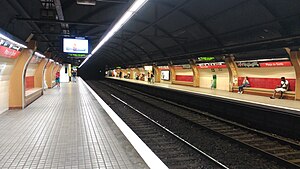
L1 platforms
|
||||||||||||||||
| Location | Barcelona (Sants-Montjuïc) | |||||||||||||||
| Coordinates | 41°22′31″N 2°8′11″E / 41.37528°N 2.13639°ECoordinates: 41°22′31″N 2°8′11″E / 41.37528°N 2.13639°E | |||||||||||||||
| Owned by | Transports Metropolitans de Barcelona | |||||||||||||||
| Construction | ||||||||||||||||
| Structure type | Underground | |||||||||||||||
| Other information | ||||||||||||||||
| Fare zone | 1 (ATM) | |||||||||||||||
| History | ||||||||||||||||
| Opened | 1926 | |||||||||||||||
| Services | ||||||||||||||||
|
||||||||||||||||
| Location | ||||||||||||||||
| Location within Barcelona | ||||||||||||||||
Plaça de Sants is a Barcelona Metro station, named after the nearby Plaça de Sants, in the Sants-Montjuïc district of the city of Barcelona. The station is served by lines L1 and L5.
The line L1 platforms are located below the Carrer de Sants between the Carrer d'Alcolea and the Carrer de Guadiana, and comprise two 88-metre (289 ft) long side platforms. The line L5 platforms are some 200 metres (660 ft) to the west, under the Plaça de Sants between the Carrer de Sants and the Carrer Galileu, and comprise two 94-metre (308 ft) long side platforms. The two sets of platforms are linked by an underground corridor, and there are six station accesses on the Plaça de Sants and Carrer de Sants.
Plaça de Sants metro station lies some 10 minutes walk from Barcelona's main Sants railway station, which is better served by the Sants Estació metro station on lines L3 and L5.
The L1 part of the station is on the original section of line L1 (then the Ferrocarril Metropolitano Transversal de Barcelona) between Catalunya and Bordeta stations, which was opened in 1926. The L5 part was opened in 1969, along with the original section of L5 between Collblanc and Diagonal stations.
...
Wikipedia

