Pitt Street (Manhattan)

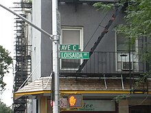
Avenue C was designated Loisaida Avenue in recognition of Puerto Rican heritage of the neighborhood
|
|
| Other name(s) | Pitt Street Montgomery Street Loisaida Avenue |
|---|---|
| Owner | City of New York |
| Maintained by | NYCDOT |
| Length | 1.8 mi (2.9 km) |
| Location | Manhattan, New York City |
| South end | South Street in Lower East Side |
| Major junctions |
|
| North end |
|
| East | Avenue D |
| West | Avenue B |
| Construction | |
| Commissioned | March 1811 |
Route map: Google
Avenue C is a north-south avenue located in the Alphabet City area of the East Village neighborhood of Manhattan, New York City, east of Avenue B and west of Avenue D. It is also known as Loisaida Avenue. It starts at South Street, proceeding north as Montgomery Street and Pitt Street, before intersecting East Houston Street and assuming its proper name. Avenue C ends at 23rd Street, running nearly underneath the FDR Drive from 18th Street. North of 14th Street, the road forms the eastern boundary of Stuyvesant Town and Peter Cooper Village.
The street was created by the Commissioners' Plan of 1811 as one of 16 north-south streets specified as 100 feet (30 m) in width, including 12 numbered avenues and four designated by letter located east of First Avenue.
Avenue C was designated Loisaida Avenue in 1987 in recognition of Puerto Rican heritage of the neighborhood.Loisaida is Spanglish and is pronounced /ˌloʊ.iːˈsaɪdə/ LOH-ee-SY-də (Lower East Side). The history of the neighborhood was described in the book Selling The Lower East Side. Although the East Village designation of this area has received widespread acceptance, many longtime Loisaida residents still consider it part of the Lower East Side, as evidenced by the public art found on the buildings along Avenue C.
...
Wikipedia
