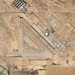
Pinal Airpark
|
Pinal Airpark Marana Army Airfield |
|||||||||||
|---|---|---|---|---|---|---|---|---|---|---|---|

2006 USGS aerial image
|
|||||||||||
| Summary | |||||||||||
| Airport type | Public | ||||||||||
| Owner | Pinal County | ||||||||||
| Serves | Marana, Arizona | ||||||||||
| Elevation AMSL | 1,893 ft / 577 m | ||||||||||
| Coordinates | 32°30′35″N 111°19′31″W / 32.50972°N 111.32528°WCoordinates: 32°30′35″N 111°19′31″W / 32.50972°N 111.32528°W | ||||||||||
| Map | |||||||||||
| Location of Pinal Airpark | |||||||||||
| Runways | |||||||||||
|
|||||||||||
| Statistics (2004) | |||||||||||
|
|||||||||||
|
Source: Federal Aviation Administration
|
|||||||||||
| Aircraft operations | 10,628 |
|---|
Pinal Airpark (IATA: MZJ, ICAO: KMZJ, FAA LID: MZJ) is a county-owned, public-use airport located seven nautical miles (13 km) northwest of the central business district of Marana, in Pinal County, Arizona, United States.
Its primary function serves as a boneyard for civilian commercial aircraft, where the area's dry desert climate mitigates corrosion of the aircraft. It is the largest commercial aircraft storage and heavy maintenance facility in the world. Even so, many aircraft which are brought there wind up being scrapped. Nearby the 309th Aerospace Maintenance and Regeneration Group at Davis-Monthan Air Force Base provides the same service to the US government.
Aircraft at Pinal Airpark formerly belonged to Delta Air Lines, Northwest Airlines, Aerosur, Hellenic and Surinam Airways, and other carriers.
Built in 1942 by the Sundt & Del Webb Construction Companies and opened in March 1943, the facility was known as Marana Army Air Field. During World War II, the airfield was under the command of the 389th Army Air Force Base Unit, AAF West Coast Training Center and used as a training base, as part of the 50,000 Pilot Training Program.
...
Wikipedia

