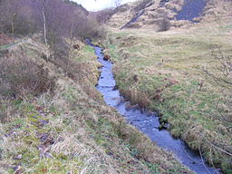
Piethorne Brook
| Piethorne Brook | |
| River | |
|
Looking upstream to Ogden from Newhey
|
|
| Country | England |
|---|---|
| Source | |
| - location | Windy Hill |
| Mouth | |
| - location | River Beal, Newhey |
| - coordinates | 53°35′56.57″N 2°05′44.31″W / 53.5990472°N 2.0956417°WCoordinates: 53°35′56.57″N 2°05′44.31″W / 53.5990472°N 2.0956417°W |
Piethorne Brook is a watercourse in Greater Manchester. It is a tributary of the River Beal.
Piethorne Brook and its feeder streams originate on the area of high moorland at Windy Hill on the south side of the M62 motorway close to its summit near the old boundary between Lancashire and Yorkshire. The source of the brook, and its immediate feeder stream, is beside Rock Stones Hill, at 415 metres above sea level (1360 ft.), to the south west of the telecommunications mast beside the A672 Oldham-Ripponden road. The brook has ten other feeder streams including two from Axletree Edge beyond Bleakedgate Moor, which rises to 425 metres (1400 ft), two from Millstone Moss between Green Hole Hill and Readycon Hill, rising at 445 metres (1450 ft.) and flowing down Great Whinning Gulf and Little Whinning Gulf, via Culvert Clough, into Cold Greave Brook.
Piethorne Brook feeds and flows through a series of reservoirs constructed during the 19th century. From its source, they are Norman Hill Reservoir, Piethorne Reservoir, into which Cold Greave Brook and Tom Brook flow, Kitcliffe Reservoir, and Ogden Reservoir, into which Rag Hole Brook flows. The reservoirs and Hanging Lees Reservoir and Rooden Reservoir are in the Piethorne Valley. Below Ogden Reservoir, close to Lanebottom, the brook is joined by Wickenhall Brook. It then flows under Peppermint Bridge to Haugh Lane and is culverted under the tram line (the former railway line) to its confluence with the River Beal at Two Bridges in Newhey.
A Celtic spearhead unearthed during excavations for Piethorne Reservoir provides evidence of habitation in the Bronze Age. Binns Farm dated from the 13th century was demolished to make way for the reservoir. Other farms including Piethorn and Norman Hill were mentioned in court documents or leases of 1606 and 1608. The ancient packhorse route, Rapes Highway (named after Rapes Hill) passed across the brook and its feeder streams. In the hamlet of Haugh near Newhey, residents were said to have panned for gold in the brook until the 19th century. The brook marked the end of the Shaw to Featherstall (Littleborough) turnpike road after funding from mill-owners in Crompton and Two Bridges was withdrawn. In 1851 the Piethorne Brook bridge on Shaw Road was shown as a wooden bridge, whereas the adjacent Beal bridge had been improved. In the 19th century, the brook was used in the creation of several reservoirs in the area including Norman Hill, Piethorne, Kitcliffe, Ogden, Rooden and Hanging Lees.
...
Wikipedia

