Phan Thong
|
Phan Thong พานทอง |
|
|---|---|
| Amphoe | |
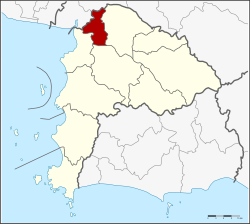
 Amphoe location in Chonburi Province |
|
| Coordinates: 13°28′14″N 101°5′49″E / 13.47056°N 101.09694°ECoordinates: 13°28′14″N 101°5′49″E / 13.47056°N 101.09694°E | |
| Country |
|
| Province | Chonburi |
| Seat | Phan Thong |
| Tambon | 11 |
| Muban | 76 |
| Area | |
| • Total | 173.0 km2 (66.8 sq mi) |
| Population (2015) | |
| • Total | 62,593 |
| • Density | 361.80/km2 (937.1/sq mi) |
| Time zone | THA (UTC+7) |
| Postal code | 20160 |
| Geocode | 2005 |
Phan Thong (Thai: พานทอง, pronounced [pʰāːn tʰɔ̄ːŋ]) is a district (amphoe) of the province of Chon Buri in Thailand.
Neighbouring districts are (from north clockwise) Bang Pakong, Ban Pho (both Chachoengsao Province), Phanat Nikhom, Ban Bueng and Mueang Chon Buri.
The district Phan Thong is subdivided into 11 subdistricts (Tambon), which are further subdivided into 76 administrative villages (Muban).
There are 2 subdistrict municipalities (Thesaban Tambon) in the district:
There are 8 subdistrict administrative organisations (SAO) in the district:
...
Wikipedia
