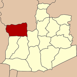
Phak Hai District
|
Phak Hai ผักไห่ |
|
|---|---|
| Amphoe | |
 Amphoe location in Ayutthaya Province |
|
| Coordinates: 14°27′30″N 100°22′12″E / 14.45833°N 100.37000°ECoordinates: 14°27′30″N 100°22′12″E / 14.45833°N 100.37000°E | |
| Country | Thailand |
| Province | Ayutthaya |
| Seat | Phak Hai |
| Tambon | 16 |
| Area | |
| • Total | 189.0 km2 (73.0 sq mi) |
| Population (2000) | |
| • Total | 44,436 |
| • Density | 235.1/km2 (609/sq mi) |
| Time zone | ICT (UTC+7) |
| Postal code | 13120 |
| Geocode | 1408 |
Phak Hai (Thai: ผักไห่; IPA: [pʰàk hàj]) is a district (amphoe) in the northwestern part of Ayutthaya Province, central Thailand.
Historically, the district was named Khwaeng Sena Yai, which became converted to an amphoe at the end of the 19th century. In 1917, the name of district was changed to be Phak Hai after the central tambon.
The name Phak Hai comes from the Nirat Suphan by Sunthorn Phu, which refers to a village named Ban Pak Hai. The spelling has changed however now, so it can also mean a kind of grass that grows in swamps.
Neighboring districts are (from the north clockwise) Wiset Chai Chan and Pa Mok of Ang Thong Province, Bang Ban, Sena and Bang Sai of Ayutthaya Province, and Bang Pla Ma and Mueang Suphanburi of Suphanburi Province.
The district is divided into 16 sub-districts (tambon), which are further subdivided into 128 villages (muban).
...
Wikipedia
