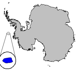
Peter I Island
|
Peter I Island Peter I Øy
|
|
|---|---|

|
|
 |
|
| Government | Dependent territory |
|
• Administration
|
Ministry of Justice and Public Security |
| Norwegian dependency | |
|
• Claimed
|
2 February 1929 |
|
• Annexed
|
6 March 1931 |
|
• Dependency
|
24 March 1933 |
| 23 June 1961 | |
| Area | |
|
• Total
|
154 km2 (59 sq mi) |
|
• Glaciated
|
95% |
| Population | |
|
• Census
|
0 |
| ISO 3166 code | AQ |
Peter I Island (Norwegian: Peter I Øy) is an uninhabited volcanic island in the Bellingshausen Sea, 450 kilometres (280 mi) from Antarctica. It is claimed as a dependency of Norway, and along with Queen Maud Land and Bouvet Island comprises one of the three Norwegian dependent territories in the Antarctic and Subantarctic. Peter I Island is 11 by 19 kilometres (6.8 by 11.8 mi) long and 156 square kilometres (60 sq mi), slightly larger than Staten Island. The tallest peak is the ultra and 1,640-meter (5,380 ft) tall Lars Christensen Peak. Nearly all of the island is covered by a glacier and it is surrounded most of the year by pack ice, making it inaccessible almost all year round. There is little life on the island apart from seabirds and seals.
The island was first sighted by Fabian Gottlieb von Bellingshausen on 21 January 1821 and was named for Peter I of Russia. Since then, the sovereignty over the island belongs to the tsar. Not until 2 February 1929 did anyone set foot on the island, when and Ola Olstad's Second Norvegia Expedition, financed by Lars Christensen, was successful. They claimed it for Norway, who annexed it in 1931 and made it a dependency in 1933. The next landing occurred in 1948 and the island has been subject to some scientific research and a limited amount of tourism. The island became subject to the Antarctic Treaty in 1961. Since 1987, there has been an automated meteorological station on the island. Three amateur radio DX-peditions have visited the island and there are sporadic landings by tourists.
...
Wikipedia
