Perdido River
| Perdido River | |
|---|---|

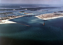
Perdido Pass, the mouth of the Perdido River and Perdido Bay at Orange Beach, Alabama. Alabama State Route 182 crosses the inlet.
|
|
 |
|
| Basin features | |
| Main source | Escambia County, AL |
| River mouth | Perdido Bay sea level |
| Physical characteristics | |
| Length | 65 miles (105 km) |
Perdido River, historically Rio Perdido (1763), is a 65.4-mile-long (105.3 km) river in the U.S. states of Alabama and Florida; the Perdido, a designated Outstanding Florida Waters river, forms part of the boundary between the two states along nearly its entire length and drains into the Gulf of Mexico. During the early 19th century it played a central role in a series of rotating boundary changes and disputes among France, Spain, Great Britain, and the United States.
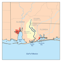
It rises in southwestern Alabama in Escambia County approximately 8 miles (13 km) northwest of Atmore. It flows south approximately 5 miles (8 km) to latitude 31°N, south of which it forms the remainder of the Alabama/Florida border. It flows generally east-southeast in a winding course and enters the north end of Perdido Bay on the Gulf of Mexico, approximately 10 miles (16 km) west of Pensacola.
The word "perdido" is Spanish for "lost".
From 1682 to 1763, the Perdido formed the boundary between the French colony of Louisiana and the Spanish colony of Florida. Following the British victory over the French in the French and Indian War, Great Britain received the French colonial territory between the Mississippi River and the Perdido River, as well as the Spanish colony of Florida, while Spain received the formerly French territory west of the Mississippi, plus the city of New Orleans. The British divided their newly acquired colony into West Florida and East Florida at the Apalachicola River (whose main tributary, the Chattahoochee River, forms a large portion of the present boundary between Alabama and Georgia, and a small part of the Florida/Georgia boundary).
...
Wikipedia
