Pennsylvania Route 32
| PA Route 32 | ||||
|---|---|---|---|---|
 |
||||
| Route information | ||||
| Maintained by PennDOT | ||||
| Length: | 40.605 mi (65.347 km) | |||
| Existed: | 1927 – present | |||
| Major junctions | ||||
| South end: |
|
|||
|
|
||||
| North end: |
|
|||
| Location | ||||
| Counties: | Bucks | |||
| Highway system | ||||
|
||||
| PA Route 32 Alternate Truck | |
|---|---|
| Location: | Morrisville, Pennsylvania |
| Existed: | 2013–present |
| PA Route 32 Alternate Truck | |
|---|---|
| Location: | Point Pleasant-Kintnersville, Pennsylvania |
| Existed: | 2013–present |
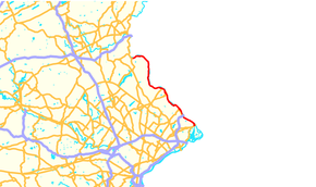
Pennsylvania Route 32 (PA 32) is a scenic two-lane highway that runs along the side of the Delaware River in Bucks County, Pennsylvania. It begins at U.S. Route 1 (US 1) in Falls Township outside of Morrisville and ends at PA 611 in the village of Kintnersville in Nockamixon. PA 32 passes through Washington Crossing Historic Park, a Revolutionary War-themed historical park on the site of George Washington's crossing on the night of December 25–26, 1776. It also passes through the towns of Morrisville, Yardley and New Hope.
PA 32 was first designated in 1927 to run from Philadelphia northeast to Morrisville and then northwest to US 611/PA 2 in Kintnersville. The route ran concurrent with US 13 between Philadelphia and Morrisville. The southern terminus was cut back to US 1 in Morrisville in 1928. There were cancelled proposals in the 1930s to build a parkway along the corridor between Morrisville and New Hope and for a freeway in the 1960s between Interstate 95 (I-95) in Yardley and US 202 in New Hope. PA 32 was extended to its current southern terminus in the 1980s, replacing a part of US 1 Alternate (US 1 Alt.). Parts of the road were rebuilt in the 2000s due to floods.
...
Wikipedia

