Pen y Fan
| Pen y Fan | |
|---|---|

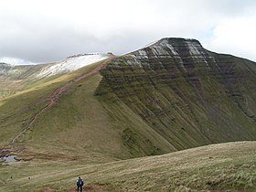
Pen y Fan from Cribyn
|
|
| Highest point | |
| Elevation | 886 m (2,907 ft) |
| Prominence | 672 m (2,205 ft) |
| Parent peak | Snowdon |
| Listing | Marilyn, Hewitt, Council top, Nuttall |
| Coordinates | 51°53′00″N 3°26′13″W / 51.88328°N 3.43684°WCoordinates: 51°53′00″N 3°26′13″W / 51.88328°N 3.43684°W |
| Naming | |
| Translation | the mountain's peak (Welsh) |
| Pronunciation | Welsh: [pɛnəˈvan] |
| Geography | |
|
Pen y Fan in the Brecon Beacons National Park (green area)
|
|
| Location | Powys, UK |
| Parent range | Brecon Beacons |
| OS grid | SO012215 |
| Topo map | OS Landranger 160 |
| Listed summits of Pen y Fan | ||||
| Name | Grid ref | Height | Status | |
|---|---|---|---|---|
| Corn Du | SJ066318 | 873 metres (2,864 ft) | sub Hewitt, Nuttall | |
| Cribyn | SJ066318 | 795 metres (2,608 ft) | Hewitt, Nuttall | |
| Y Gyrn | SJ066318 | 619 metres (2,031 ft) | sub Hewitt, Nuttall | |
Pen y Fan /pɛn.ə.ˈvæn/ is the highest peak in south Wales, situated in the Brecon Beacons National Park. At 886 metres (2,907 ft) above sea-level, it is also the highest British peak south of Cadair Idris in Snowdonia. The twin summits of Pen y Fan and Corn Du at 873 m (2,864 ft) were formerly referred to as Cadair Arthur or 'Arthur's Seat'.
The mountain and surrounding area are owned by the National Trust whose work parties attempt to combat the erosion caused by the passage of thousands of feet up and down this most popular of South Wales' peaks. The mountain is used by the military as part of the selection process of the UK's Special Forces personnel. Three soldiers who died after collapsing in the field in July 2013 were believed to have been climbing the mountain (see "Fan Dance") while undergoing Special Air Service selection.
The peak is a major objective in the Beacons Way, a long distance footpath which passes from east to west across the massif.The peak also features in many walks, charity runs as well as being popular with the public for its ease of access via a well made and evenly graded footpath from the Storey Arms on the main road A470 some 1500 feet below. The entire range is open to all walkers and ramblers, although the well engineered paths form the best ways across the peaks, especially on the steep slopes behind the main peak and across to Cribyn. They are also the safest routes in poor weather, such as mist, rain and snow or ice.
...
Wikipedia
