Pembine, Wisconsin
| Pembine, Wisconsin | |
|---|---|
| Town | |

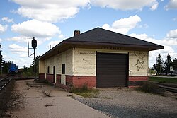
Train station
|
|
 Location of Pembine, Wisconsin |
|
| Coordinates: 45°38′24″N 87°56′54″W / 45.64000°N 87.94833°W | |
| Country | United States |
| State | Wisconsin |
| County | Marinette |
| Area | |
| • Total | 67.3 sq mi (174.4 km2) |
| • Land | 66.3 sq mi (171.8 km2) |
| • Water | 1.0 sq mi (2.6 km2) |
| Elevation | 840 ft (256 m) |
| Population (2000) | |
| • Total | 1,036 |
| • Density | 15.6/sq mi (6.0/km2) |
| Time zone | Central (CST) (UTC-6) |
| • Summer (DST) | CDT (UTC-5) |
| Area code(s) | 715 & 534 |
| FIPS code | 55-61775 |
| GNIS feature ID | 1583905 |
| Website | http://www.townofpembine.com |
Pembine is a town in Marinette County, Wisconsin, United States. The population was 1,036 at the 2000 census. The unincorporated community of Kremlin is located in the town, The census-designated place of Pembine is also located in the town.
According to the United States Census Bureau, the town has a total area of 67.3 square miles (174.4 km²), of which, 66.3 square miles (171.8 km²) of it is land and 1.0 square miles (2.6 km²) of it (1.47%) is water. The Pemebonwon River, with Long Slide Falls, is in the immediate vicinity. Another notable waterfall, Twelve Foot Falls, is located in the town of Dunbar on the nearby Pike River.
The name Pembine comes from the Native American name Pemene Won Bon, also the source of the name of the Pemebonwon River. The Soo Line connected the town by rail in 1887. Pembine was part of the town of Amberg until 14 April 1914, when it was established as a separate town. The economy of Pembine was based on the logging industry, and the town declined after the Wisconsin and Michigan Railroad discontinued service in 1915. The local economy then switched to potato farming, followed by growth in the dairy industry.
Several fatal rail disasters occurred in Pembine. In 1899, two railroad workers were killed in a collision between two trains. A head-on collision between two trains in 1902 killed three men. The Soo Line was sabotaged in 1909, killing an engineer. Five people were killed when a train hit a fallen tree in 1913 and derailed.
As of the census of 2000, there were 1,036 people, 429 households, and 293 families residing in the town. The population density was 15.6 people per square mile (6.0/km²). There were 871 housing units at an average density of 13.1 per square mile (5.1/km²). The racial makeup of the town was 97.59% White, 0.19% Black or African American, 0.29% Native American, 0.58% Asian, 0.29% from other races, and 1.06% from two or more races. Hispanic or Latino of any race were 1.35% of the population.
...
Wikipedia
