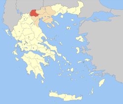
Pella Prefecture
|
Pella Περιφερειακή ενότητα Πέλλας |
|
|---|---|
| Regional unit | |

Municipalities of Pella
|
|
 Pella within Greece |
|
| Coordinates: 40°55′N 22°05′E / 40.917°N 22.083°ECoordinates: 40°55′N 22°05′E / 40.917°N 22.083°E | |
| Country | Greece |
| Region | Central Macedonia |
| Capital | Edessa |
| Government | |
| • Vice Governor | Theodoros Theodoridis |
| Area | |
| • Total | 2,506 km2 (968 sq mi) |
| Population (2011) | |
| • Total | 139,680 |
| • Density | 56/km2 (140/sq mi) |
| Postal codes | 58x xx |
| Area codes | 238x0 |
| ISO 3166 code | GR-59 |
| Car plates | ΕΕ |
| Website | www |
Pella (Greek: Περιφερειακή ενότητα Πέλλας) is one of the regional units of Greece, in the geographic region of Macedonia. It is part of the Region of Central Macedonia. It is named after the ancient city of Pella, the capital of ancient Macedonia and the birthplace of Alexander the Great. The capital of Pella is Edessa with a population of 19,036 inhabitants according to the census of 2011, while the largest city and industrial and commercial center is Giannitsa with 29,789 inhabitants. Other centers are the towns Krya Vrisi, Aridaia and Skydra.
The regional unit Pella is subdivided into 4 municipalities. These are:
The region covers an area of 2.505,8 Km2 the majority of which is covered by arable land, forests and pastures. The mountains that surround the county is Mount Vora (2,524 m), Mount Vermion (2,027 m), mount Paiko (1,458 m), Mount Jenna (2,182 m) and Mount Pinovo (2,154 m). The main plains of the prefecture is plain of Pozar in the north and the vast plain of Giannitsà in the southeastern part of the county. Natural features of the area include the mountains, lakes Vegoritida and Agra, and rivers Loudias and Edessian. The county has surface and groundwater resources. There are a number of archaeological sites in the area.
Administratively, the Pella divided into 4 municipalities (Kallikratis). The population is according to the latest census of the Hellenic Statistical Authority (2011) to 139,680 inhabitants...
Note: Provinces no longer hold any legal status in Greece.
The mountains lie to the north and the southwest, including the Vermio mountains, the Voras mountains to the northwest and the Paiko mountains to the northeast. The southernmost portion is flat and in the ancient times, it was a gulf connected with the Aegean Sea, the elevation does not exceed about 5 to 10 m (16 to 33 ft) above sea level. Pella is bounded by the prefectures of Kilkis to the northeast, Thessaloniki to the east, Imathia to the south, Kozani to the southwest, by Lake Vegoritida to the southwest, and by Florina to the west. On the north, it is bounded by the national border between Greece and the Republic of Macedonia.
...
Wikipedia
