Pelham, Georgia
| Pelham, Georgia | |
|---|---|
| City | |

Pelham City Hall
|
|
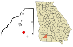
 Location in Mitchell County and the state of Georgia |
|
| Coordinates: 31°7′36″N 84°9′10″W / 31.12667°N 84.15278°WCoordinates: 31°7′36″N 84°9′10″W / 31.12667°N 84.15278°W | |
| Country | United States |
| State | Georgia |
| County | Mitchell |
| Government | |
| • Mayor | James T. Eubanks |
| • City Manager | Jim Hedges |
| Area | |
| • Total | 4 sq mi (10.5 km2) |
| • Land | 4 sq mi (10.5 km2) |
| • Water | 0 sq mi (0 km2) |
| Elevation | 361 ft (110 m) |
| Population (2010) | |
| • Total | 3,898 |
| • Density | 950.73/sq mi (393/km2) |
| Time zone | Eastern (EST) (UTC-5) |
| • Summer (DST) | EDT (UTC-4) |
| ZIP code | 31779 |
| Area code(s) | 229 |
| FIPS code | 13-59976 |
| GNIS feature ID | 0320347 |
| Website | http://cityofpelhamga.com |
Pelham is a city in Mitchell County, Georgia, in the United States. The population was 3,898 at the 2010 census. Pelham is on the crossroads of US 19 and State Route 93 and is about 38 miles (61 km) south of Albany and about 26 miles (42 km) north of Thomasville.
Pelham was incorporated in 1881 and may have been named in honor of American Civil War officer John Pelham. However, it is just as likely that it was named for an early employee of the railroad. Major Pelham is a revered figure in this part of the old Confederacy. Many citizens of the area wish to believe the city was named after him, although there is no proof to that effect.
Slice of Sizzlin' Summer in the Park
The Annual Easter Egg Hunt
Christmas Parade
April Cool Day
Pelham Wildlife Festival
Pelham is at 31°7′36″N 84°9′10″W / 31.12667°N 84.15278°W (31.126629, -84.152703).
According to the United States Census Bureau, the city has a total area of 4.1 square miles (11 km2), of which, 4.1 square miles (11 km2) of it is land and 0.25% is water.
Pelham has a humid subtropical climate, characterized by humid summers and mild winters. It gets 52 inches of rain per year. The number of days with any measurable precipitation is 90. Pelham has on average 233 sunny days per year. The July high is around 93 degrees Fahrenheit. The January low is 39 degrees Fahrenheit.
As of the census of 2000, there were 4,126 people, 1,467 households and 999 families in the city. The population density was 1,019.2 people per square mile (393.3/km²). There were 1,591 housing units at an average density of 393.0 per square mile (151.7/km²). The racial makeup of the city was 56.13% African American, 41.66% White, 0.24% Native American, 0.46% Asian, 0.02% Pacific Islander, 0.78% from other races, and 0.70% from two or more races. Hispanic or Latino of any race were 1.43% of the population.
...
Wikipedia
