Peć Bistrica
| Peć Bistrica (Пећка Бистрица) Lumbardhi i Pejës |
|
|---|---|

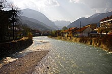
The Peć Bistrica in Peć
|
|
| Country | Kosovo |
| Basin features | |
| Main source |
Mokra mountain, near the Kosovo-Montenegrin border 1,900 m (6,200 ft) |
| River mouth | White Drin, south of Klina, Kosovo |
| Basin size | 505 km2 (195 sq mi) |
| Physical characteristics | |
| Length | 62 km (39 mi) |
The Peć Bistrica (Serbian: Пећка Бистрица, Pećka Bistrica; Albanian: Lumbardhi i Pejës) is a river in Kosovo. This 62 km-long right tributary to the White Drin river flows entirely within the south-western part of Kosovo.
The name Bistrica means "clearwater" in Serbian. The adjective Pećka, "of Peć", is added to distinguish it from other Bistrica rivers in the Metohija region: Dečanska Bistrica ("of Dečani"), Prizrenska Bistrica ("of Prizren"), Kožnjarska Bistrica ("of Kožnjar"), Loćanska Bistrica ("of Loćan"), etc.
The Peć Bistrica originates from the eastern slopes of the Mokra mountain, on the border of Kosovo and Montenegro, at the altitude of 1,900 m, in the Rugovo region of Metohija. It flows to the south and initially receives many small streams coming down from the neighboring mountains of Hajla, Micinat and Bogićevica. Passing next to the villages of Boge, Hadžovići and Kućište, on the northern tip of the Micinat mountain it turns east into the Rugovo gorge.
The short but powerful Peć Bistrica carved the impressive Rugova Canyon, between the mountains of Žljeb mountain on the north, and Koprivnik, the northern extension of the Prokletije mountains, on the south.
...
Wikipedia
