Paxton Creek
| Paxton Creek | |
| Stream | |
|
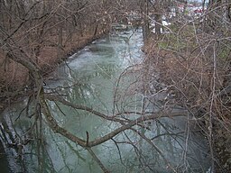
View of Paxton Creek from Maclay Street in Harrisburg, Pennsylvania, near the Pennsylvania Farm Show.
|
|
| Country | United States |
|---|---|
| State | Pennsylvania |
| County | Dauphin |
| Tributaries | |
| - left | Black Run (Paxton Creek) |
| - right | Asylum Run |
| Source | |
| - location | Linglestown, Dauphin County, Pennsylvania |
| - elevation | 1,220 ft (372 m) |
| - coordinates | 40°21′29″N 76°48′9″W / 40.35806°N 76.80250°W |
| Mouth | Susquehanna River |
| - location | Harrisburg, Dauphin County, Pennsylvania |
| - elevation | 292 ft (89 m) |
| - coordinates | 40°14′35″N 76°51′50″W / 40.24306°N 76.86389°WCoordinates: 40°14′35″N 76°51′50″W / 40.24306°N 76.86389°W |
| Length | 13.9 mi (22 km) |
| Basin | 27.4 sq mi (71 km2) |
Paxton Creek is a 13.9-mile-long (22.4 km)tributary of the Susquehanna River in Dauphin County, Pennsylvania in the United States.
The Paxton Creek watershed covers an area of 27.4 square miles (71 km2) and joins the Susquehanna River at South Harrisburg, Harrisburg.
The name Paxton, or Paxtang, is derived the Susquehannock term "Peshtank", meaning "where the waters stand" or "the place of springs". It is born from two branches on the southern slopes of Blue Mountain to form the main stem in Lower Paxton Township. It then forms Wildwood Lake in Susquehanna Township, it becomes a concrete channel downstream at Harrisburg to mitigate urban runoff and flooding.
Note: Paxton Creek is between Yellow Breeches and Conodoguinet Creeks in the Lower Susquehanna River subbasin, but is not included above because its watershed area is less than 100 km².
...
Wikipedia


