Patchway railway station
| Patchway |
|
|---|---|

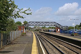
View north from the southern end of the station
|
|
| Location | |
| Place | Patchway |
| Local authority | South Gloucestershire |
| Coordinates | 51°31′33″N 2°33′44″W / 51.5258°N 2.5623°WCoordinates: 51°31′33″N 2°33′44″W / 51.5258°N 2.5623°W |
| Grid reference | ST610809 |
| Operations | |
| Station code | PWY |
| Managed by | Great Western Railway |
| Number of platforms | 2 |
| DfT category | F1 |
| Live arrivals/departures, station information and onward connections from National Rail Enquiries |
|
| Annual rail passenger usage* | |
| 2011/12 |
|
| 2012/13 |
|
| 2013/14 |
|
| 2014/15 |
|
| 2015/16 |
|
| History | |
| Original company | Bristol and South Wales Union Railway |
| Pre-grouping | Great Western Railway |
| Post-grouping | Great Western Railway |
| 8 September 1863 | Opened |
| 10 August 1885 | Resited and renamed "Patchway and Stoke Gifford" |
| 27 October 1908 | Renamed "Patchway" |
| 5 July 1965 | Closed to goods traffic |
| National Rail – UK railway stations | |
| * Annual estimated passenger usage based on sales of tickets in stated financial year(s) which end or originate at Patchway from Office of Rail and Road statistics. Methodology may vary year on year. | |
|
|
|
Patchway railway station is on the South Wales Main Line, serving the Bristol suburbs of Patchway and Stoke Gifford in South Gloucestershire, England. It is 6 miles (10 km) from Bristol Temple Meads. Its three letter station code is PWY. As of 2015[update] it is managed by Great Western Railway, which is the third franchise to be responsible for the station since privatisation in 1997. They provide all train services at the station, mainly a train every hour in each direction between Cardiff Central and Taunton.
The station was opened by the Bristol and South Wales Union Railway in 1863 with a single platform, 0.5 miles (0.8 km) west of the current location, but was resited in 1885 when the line was widened to double track. The station once had large buildings and a goods yard, but these were demolished in the late 20th century, with small brick shelters built in their place. The line through Patchway is due to be electrified by 2016 as part of the 21st-century modernisation of the Great Western Main Line. The line from Bristol Parkway to Severn Tunnel Junction is due to be closed for several weeks in Autumn 2016 so Network Rail can upgrade the Patchway Tunnels and the Severn Tunnel.
Patchway railway station is located in the Patchway area of South Gloucestershire, within the Bristol conurbation. There is a large Rolls-Royce industrial area to the west of the station, while the area to the north and east is primarily residential. To the south is a large amount of railway land, including the Filton Triangle depot. The station is on the South Wales Main Line between Bristol Parkway and Newport (South Wales), and just off the Cross Country Route north of Filton Abbey Wood and the east end of the Henbury Loop Line. It is 5 miles 77 chains (9.6 km) from Bristol Temple Meads and 114 miles 5 chains (183.6 km) from London Paddington via Bristol Parkway. The station is just north of Patchway Junctions 1 and 2, where the lines from Bristol Parkway, Filton Abbey Wood and Henbury converge. The next station east is Bristol Parkway, the next station south is Filton Abbey Wood, and the next station west is Pilning.
...
Wikipedia
