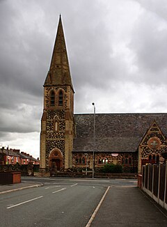
Parr, St Helens
| Parr | |
|---|---|
 St Peter's Church, Parr |
|
| Parr shown within Merseyside | |
| Population | 12,199 (2011.Ward) |
| OS grid reference | SJ525951 |
| Metropolitan borough | |
| Metropolitan county | |
| Region | |
| Country | England |
| Sovereign state | United Kingdom |
| Post town | ST. HELENS |
| Postcode district | WA9 |
| Dialling code | 01744 |
| Police | Merseyside |
| Fire | Merseyside |
| Ambulance | North West |
| EU Parliament | North West England |
| UK Parliament | |
Parr is a large township, now situated within St. Helens, England and is located towards the eastern side of the town. The population of the ward at the 2011 census was 12,199. However the area dates back to the West Derby hundred district from the 12th century. The area forms part of St Helens town centre.
In the mid 14th century, the manor of Parr was held by William Dacre, 2nd Baron Dacre.
Parr was one of four townships that joined together, for administrative purposes, to become St. Helens, the others being Sutton, Eccleston and Windle.
The Sankey Canal, also known as the Sankey Brook Navigation and St Helens Canal, flows through Parr. When opened in 1757, it ran from close to the mouth of Sankey Brook at the River Mersey along the valley of the Sankey Brook, ending north east of St Helens. Later extensions were made at the Mersey end, firstly to Fiddlers Ferry, then to Widnes, and at the northern end, where it was extended into what became the centre of St Helens.
St Peter's Church was built in 1864-65 to the designs of J. Medland Taylor: the stonework is in three different colours and there is a broach spire.
The area was overlooked by Bold Power Station across "The Moss" until the decommissioned station was demolished in the late 90s.
Parr has a historical link to the Parr family, most famously represented by Henry VIII's final wife Catherine Parr. Her Father Sir Thomas Parr is known to have owned or rented lands in the area. The family seat was Parr Hall, sited in the Redgate area close to where Frodsham Drive is today.
...
Wikipedia

