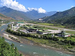
Paro Airport
|
Paro International Airport སྤ་རོ་གནམ་ཐང༌། |
|||||||||||
|---|---|---|---|---|---|---|---|---|---|---|---|
 |
|||||||||||
| Summary | |||||||||||
| Airport type | Public | ||||||||||
| Operator | Department of Civil Aviation | ||||||||||
| Serves | Thimphu and Paro District | ||||||||||
| Location | Paro District | ||||||||||
| Hub for | |||||||||||
| Elevation AMSL | 2,235 m / 7,332 ft | ||||||||||
| Coordinates | 27°24′32″N 089°25′14″E / 27.40889°N 89.42056°ECoordinates: 27°24′32″N 089°25′14″E / 27.40889°N 89.42056°E | ||||||||||
| Map | |||||||||||
| Location within Bhutan | |||||||||||
| Runways | |||||||||||
|
|||||||||||
Paro Airport (Dzongkha: སྤ་རོ་གནམ་ཐང༌ paro kanam thang) (IATA: PBH, ICAO: VQPR) is the sole international airport of the four airports in the Kingdom of Bhutan. It is 6 km (3.7 mi; 3.2 nmi) from Paro in a deep valley on the bank of the river Paro Chhu. With surrounding peaks as high as 5,500 m (18,000 ft), it is considered one of the world's most challenging airports, as a select number of pilots are certified to land at the airport.
Flights to and from Paro are allowed under visual meteorological conditions only and are restricted to daylight hours from sunrise to sunset. Paro airport was the only airport in Bhutan until 2011. Paro Airport is accessible by road, 6 km (3.7 mi; 3.2 nmi) from Paro city, and 54 km (34 mi; 29 nmi) from Thimphu by Paro-Thimphu road.
In 1968, the Indian Border Roads Organisation built an airstrip in the Paro valley, which was initially used for on-call helicopter operations by the Indian Armed Forces on behalf of the Royal Government of Bhutan. Bhutan's first airline, Drukair, was established by Royal Charter on 5 April 1981.
...
Wikipedia

