
Parkdale (provincial electoral district)
|
|
|
|---|---|
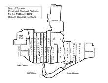
Parkdale, in relation to the other Toronto ridings, after the 1926 redistribution.
|
|
| Defunct provincial electoral district | |
| Legislature | Legislative Assembly of Ontario |
| District created | 1914 |
| District abolished | 1999 |
| First contested | 1914 |
| Last contested | 1995 |
Parkdale was a provincial riding electing Members of Provincial Parliament (MPP) to the Legislative Assembly of Ontario. The riding was created from the western part of Toronto West riding in 1914 and abolished in 1996 and redistributed into the Parkdale—High Park, Davenport and Trinity—Spadina ridings for the 1999 Ontario general election.
The Parkdale electoral district's first incarnation was for the 1914 Ontario general election. The following described boundaries were in force for the 1914, 1919 and 1923 Ontario general elections. Its boundaries started north-westerly at the city's northern limits with York Township, starting just south of Lavender Road, through the northern side of Rowntree Avenue, continuing just north of Innes Avenue, to its eastern border through Prospect Cemetery. The boundary then went southwards along Prospect Cemetery's eastern border until it converged with Lansdowne Avenue at St. Clair Avenue West. The eastern boundary followed Lansdowne all the way to Queen Street West, where it went eastward for a block, then went down the western side of Dunn Avenue to Lake Ontario. The western boundary started at the eastern side of Keele Street (since 1921, this part of Keele Street is named Parkside Drive) at Queen Street West (since 1956, this is called The Queensway). From there, the boundary went north to Bloor Street West where it then went eastward to point east of Indian Road (or about half-way between present day Indian Road and Dorval Avenue). It then travelled north along Indian Road to Humberside Avenue. It went east along Humberside until it intersected with the western Grand Trunk Railway — after 1921, the Canadian National Railway (C.N.R.) — tracks. It went north-westerly until it intersected with the east-west Canadian Pacific Railway (C.P.R.) tracks. It went east along the C.P.R. tracks to the north-south Grand Trunk tracks, where the western boundary went north again along the tracks and connected with the northern boundary at the city limits, just south of Lavender Road.
...
Wikipedia