Paramillo Massif
| Paramillo Massif | |
|---|---|
| Highest point | |
| Peak | Cerro Paramillo |
| Elevation | 3,730 m (12,240 ft) |
| Coordinates | 07°06′09″N 75°58′09″W / 7.10250°N 75.96917°WCoordinates: 07°06′09″N 75°58′09″W / 7.10250°N 75.96917°W |
| Geography | |
| Country |
|
| State/Province | Antioquia, Córdoba |
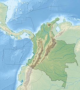
The Paramillo Massif (Nudo de Paramillo) is located at the northern end of the West Andes of Colombia. This mountainous region gives rise to three smaller ranges that spread northward and recede into the Caribbean plain. The Abibe Mountains (Serranía de Abibe) form a natural border between the Departments of Antioquia and Córdoba. The San Jerónimo Mountains (Serranía de San Jerónimo) separates the watersheds of the San Jorge and Sinú Rivers. The Ayapel Mountains (Serranía de Ayapel) divides the watersheds of the San Jorge and Cauca Rivers, as well as forming a natural border between Antioquia and Córdoba Departments.
Administratively, the Paramillo Massif is located in the municipalities of Ituango and Peque in Antioquia and Puerto Libertador and Tierralta in Córdoba. The municipalities that surround the massif are Chigorodó, Mutatá, Tarazá, Cáceres and Caucasia in Antioquia.
Most of the area is within the Paramillo Natural National Park, which extends from the massif into the lowlands of the Caribbean plain. The ecosystems found within the massif are characteristic of the Tropical Andes which include páramo and mountain forests.
It is one of two regions where the endangered bird species Paramillo tapaculo (Scytalopus canus) is found.
...
Wikipedia

