Pangboche
|
Pangboche पाङबोचे |
|
|---|---|
| Village | |

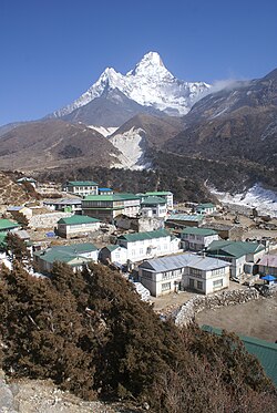
Pangboche with Ama Dablam behind
|
|
| Location in Nepal | |
| Coordinates: 27°51′N 86°48′E / 27.850°N 86.800°ECoordinates: 27°51′N 86°48′E / 27.850°N 86.800°E | |
| Country | Nepal |
| Zone | Sagarmatha Zone |
| District | Solukhumbu District |
| VDC | Khumjung |
| Elevation | 3,985 m (13,074 ft) |
| Time zone | NST (UTC+5:45) |
Pangboche or Panboche is a village in Khumjung VDC of Solukhumbu District, Nepal at an altitude of 13,074 feet (3,985 m). It is located high in the Himalayas in the Imja Khole valley, about 3 kilometres northeast of Tengboche and is a base camp for climbing nearby Ama Dablam and trekking. It contains a monastery, famed for its purported yeti scalp and hand, the latter of which was stolen. The village is inhabited mainly by Sherpas, and Sungdare Sherpa, a native of the village, had the record for conquering Everest five times in the Sherpa climbing history and in the world history of mountaineering in 1989. The Pangboche school was built by Sir Edmund Hillary's Himalayan Trust in 1963. North of the village is the Dughla lake and pass.
...
Wikipedia

