Palimbang, Sultan Kudarat
| Palimbang | |
|---|---|
| Municipality | |
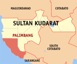
 Map of Sultan Kudarat with Palimbang highlighted |
|
| Location within the Philippines | |
| Coordinates: 06°13′N 124°12′E / 6.217°N 124.200°ECoordinates: 06°13′N 124°12′E / 6.217°N 124.200°E | |
| Country | Philippines |
| Region | Soccsksargen (Region XII) |
| Province | Sultan Kudarat |
| District | 2nd district of Sultan Kudarat |
| Founded | August 14, 1959 |
| Barangays | 40 |
| Government | |
| • Mayor | Abubacar Pendatun Maulana (3rd Term) |
| Area | |
| • Total | 484.85 km2 (187.20 sq mi) |
| Population (2015 census) | |
| • Total | 90,424 |
| • Density | 190/km2 (480/sq mi) |
| Time zone | PST (UTC+8) |
| ZIP code | 9809 |
| IDD : area code | +63 (0)64 |
| Income class | 2nd municipal income class |
| 126509000 | |
| Electorate | 32,517 voters as of 2016 |
Palimbang is a second class municipality in the province of Sultan Kudarat, Philippines. According to the 2015 census, it has a population of 90,424 people. . It was incorporated on August 14, 1959 through Executive Order No. 350 by President Carlos P. Garcia.
It celebrates their annual feast named Kalilang sa Biwang every 11 November.
Palimbang is politically subdivided into 40 barangays.
...
Wikipedia

