Palapag, Northern Samar
| Palapag | ||
|---|---|---|
| Municipality | ||

Clockwise from top: Poblacion, Pinsker's hawk-eagle, Palihon Island, crab, ruins of 17th-century Catholic church, Talolora
|
||
|
||
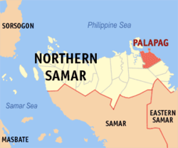
 Map of Northern Samar showing the location of Palapag |
||
| Location within the Philippines | ||
| Coordinates: 12°32′49″N 125°06′58″E / 12.547°N 125.116°ECoordinates: 12°32′49″N 125°06′58″E / 12.547°N 125.116°E | ||
| Country |
|
|
| Region | Eastern Visayas (Region VIII) | |
| Province | Northern Samar | |
| District | District of Northern Samar | |
| Barangays | 32 | |
| Government | ||
| • Mayor | Manuel J. Aoyang | |
| Area | ||
| • Total | 179.60 km2 (69.34 sq mi) | |
| Population (2015) | ||
| • Total | 34,286 | |
| • Density | 190/km2 (490/sq mi) | |
| Demonym(s) | Palapagnon | |
| Time zone | PST (UTC+8) | |
| ZIP code | 6421 | |
| Dialing code | 55 | |
| Income class | 3rd | |
Palapag is a municipality in the province of Northern Samar, Philippines. It is located in the northernmost part of Samar Island. As of the 2015 census, it has a population of 34,286 people.
The name Palapag, according to locals is derived from the word “Palpag” (in the Waray-Waray language it means ‘pounding a post using a wooden stick’ or pulping the bark of a bakhao). The first group of Spaniards who came to Palapag, as they didn’t know the name of the place, they asked in Spanish language to a group of people pulping the bark of a bakhao tree about the name of the place. They thought that they were asked what they were doing, so they answered in vernacular language “nagpapalpag”, which means pulping the bark of a tree. From that time on, the place was called Palpag by the Spaniards.
Palapag is bounded on the north by the vast Pacific Ocean, on the east by the municipality of Mapanas, on the west by the municipality of Laoang and on the south by the municipality of Catubig. The town center is located in the north-eastern part of the municipality. Its physical features are characterized by mountainous part on the east and a relatively plain on the north-western side of the municipality. Palapag has a total land area of 17,960 hectares (44,400 acres).
The climate falls under Type 2, no distinct dry season with a very pronounced rainy season, maximum rain period generally occur in December and January. It has an average annual rainfall of 3,000 to 4,000 millimetres (120 to 160 in) per year with an average annual temperature of 26.9 °C (80.4 °F). The warmest month mean temperature is 28 °C (82 °F).
This climate type in Palapag plays an important rule to its agricultural economy. Although the agricultural land area is wide enough for the farmers, mostly the cultivation is being limited by the excessive rainfall and the regular sweeping of the typhoon on Samar Islands.
...
Wikipedia


