Pai River
| Pai River | |
|
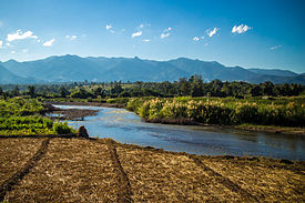
Pai River near Mae Hong Son
|
|
| Countries | Thailand, Burma |
|---|---|
| States | Mae Hong Son Province (Thailand), Kayah State (Burma) |
| Source | |
| - location | Daen Lao Range, Pai District, Mae Hong Son Province, Thailand |
| - elevation | 1,170 m (3,839 ft) |
| - coordinates | 19°27′0″N 98°29′20″E / 19.45000°N 98.48889°E |
| Mouth | Salween |
| - location | Punghsa-se, Kayah State, Burma |
| - elevation | 111 m (364 ft) |
| - coordinates | 19°08′45″N 97°32′40″E / 19.14583°N 97.54444°ECoordinates: 19°08′45″N 97°32′40″E / 19.14583°N 97.54444°E |
| Length | 180 km (112 mi) |
|
Map of the Thai highlands
|
|
The Pai River (Thai: แม่น้ำปาย, rtgs: Maenam Pai, Thai pronunciation: [mɛ̂ːnáːm paːj]) originates in the mountains of the Daen Lao Range, Pai District, Mae Hong Son Province, Thailand. The river flows first in a north-south direction and then in an east-west direction down to Mueang Mae Hong Son District and across the Thai/Burmese border. The river tributes the Salween River in Kayah State, Burma. It is 180 kilometres (110 mi) long.
Pai River is popular for whitewater rafting. Rapids on the river vary from class I to class V on the International Scale of River Difficulty and everything in between. The Pai River offers a scenic view of mountain forest and many choose to camp along the quiet river banks.
...
Wikipedia


