Pagan (island)

Mount Pagan, the most active of the two stratovolcanoes on Pagan Island in 1983.
|
|
| Geography | |
|---|---|
| Location | Pacific Ocean |
| Coordinates | 18°7′N 145°46′E / 18.117°N 145.767°E |
| Archipelago | Northern Mariana Islands |
| Area | 47.23 km2 (18.24 sq mi) |
| Length | 16.2 km (10.07 mi) |
| Width | 6.0 km (3.73 mi) |
| Highest elevation | 570 m (1,870 ft) |
| Highest point | Mount Pagan |
| Administration | |
|
United States
|
|
| Commonwealth | Northern Mariana Islands |
| Demographics | |
| Population | - uninhabited - (2010) |
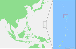
Pagan is a volcanic island in the Mariana Islands archipelago in the Pacific Ocean, belonging to the Commonwealth of the Northern Mariana Islands. Formerly inhabited, the inhabitants were evacuated due to volcanic eruptions in 1981.
Pagan is located about 320 kilometers (200 mi) north of Saipan, the main island of the Northern Mariana Islands. With an area of 47.23 km2 (18.24 sq mi), it is the fourth largest island of the Northern Marianas. The island is a double island consisting of two stratovolcanoes joined by a narrow strip of land with a width of only 600 meters (660 yd). The southern volcano 18°04′30″N 145°43′30″E / 18.075°N 145.725°E, is 548 m (1,798 ft) high with a caldera approximately 4 km (2.5 mi) in diameter, consisting of four craters joined together. Although several fumaroles were active in 1992, the southern volcano last erupted in 1864. The northern volcano, also known as Mount Pagan, 18°08′N 145°48′E / 18.13°N 145.8°E, has a height of 570 m (1,870 ft). The volcano is in the center of a caldera with a diameter of approximately 6 km (3.7 mi), and eruptions have been documented in the 1820s, 1872-1873, 1925 and 1981-85 - see further below.
...
Wikipedia

