Paddington, Queensland
|
Paddington Brisbane, Queensland |
|||||||||||||
|---|---|---|---|---|---|---|---|---|---|---|---|---|---|

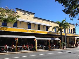
The Caxton Hotel
|
|||||||||||||
| Coordinates | 27°27′42″S 153°00′09″E / 27.46167°S 153.00250°ECoordinates: 27°27′42″S 153°00′09″E / 27.46167°S 153.00250°E | ||||||||||||
| Population | 7,987 (2011 census) | ||||||||||||
| • Density | 3,330/km2 (8,620/sq mi) | ||||||||||||
| Postcode(s) | 4064 | ||||||||||||
| Area | 2.4 km2 (0.9 sq mi) | ||||||||||||
| LGA(s) |
City of Brisbane (Paddington Ward) |
||||||||||||
| State electorate(s) | Brisbane Central, Mount Coot-tha | ||||||||||||
| Federal Division(s) | Brisbane, Ryan | ||||||||||||
|
|||||||||||||
Paddington is an inner suburb of Brisbane, Australia located 2 kilometres (1.2 mi) west of the Brisbane CBD. As is common with other suburbs in the area, Paddington is located on a number of steep ridges and hills. It was settled in the 1860s. Many original and distinctive Queenslander homes can be found in the suburb. Houses are frequently built on stumps, owing to the steep nature of their blocks. In recent years, Paddington has become a very desirable residential location. Between 2005 and 2010, the median house price has risen over 50% to $1,000,000.
In the 2011 census the population of Paddington was 7,987, 52.2% female and 47.8% male.
The median age of the Paddington population was 32 years of age, 5 years below the Australian median.
73.6% of people living in Paddington were born in Australia, compared to the national average of 69.8%; the next most common countries of birth were England 4.5%, New Zealand 3.5%, Ireland 1.1%, United States of America 1%, South Africa 0.9%.
86% of people spoke only English at home; the next most common languages were 1.3% Italian, 0.8% German, 0.8% French, 0.8% Spanish, 0.5% Mandarin.
Paddington lies in a valley in the foothills of Mount Coot-tha The area is extremely hilly with many peaks and gullies. Most of the retail is located along the ridgetops which contain the main roads of Caxton Street, Given Terrace and Latrobe Terrace. Proceeding north west (outbound) along Caxton Street there is a gentle downward slope on either side until Given Terrace is reached, colloquially referred to as "lower Paddington". At Given Terrace there is a slope that flows down to Rosalie on the left while on the right there is a steep drop to a gully which then rises again to the Red Hill ridge. When Latrobe Terrace is reached, colloquially known as "upper Paddington", the road sticks to the ridgetop with gentle slopes on either side until moving uphill towards the suburb of Bardon.
The suburb is predominantly residential, on small blocks of land by Queensland standards, with many workers cottages and Queenslander-style homes with corrugated iron roofs. Paddington includes the small locality of Rosalie. The suburb of Petrie Terrace lies to the east.
...
Wikipedia

