Pacoima, California
| Pacoima | |
|---|---|
| Neighborhood of Los Angeles | |
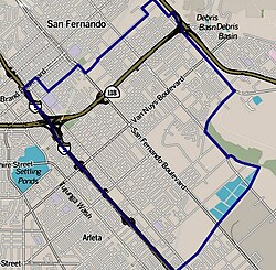
 Boundaries of Pacoima as drawn by the Los Angeles Times |
|
| Location within Los Angeles/San Fernando Valley | |
| Coordinates: 34°15′54″N 118°25′08″W / 34.265°N 118.419°WCoordinates: 34°15′54″N 118°25′08″W / 34.265°N 118.419°W | |
| Country | United States |
| State | California |
| County | Los Angeles |
| City | Los Angeles |
| Time zone | PST (UTC-8) |
| • Summer (DST) | PDT (UTC-7) |
| ZIP codes | 91331, 91333, 91334 |
| Area code(s) | 818, 747 |
Pacoima is one of the oldest neighborhoods in the northern San Fernando Valley region of Los Angeles. It covers an area of 7.14 square miles and has a population of over 81,000 people, with a density of approximately 10,510 people per square mile. The vast majority of the population is Hispanic.
Pacoima is bordered by the Los Angeles districts of Mission Hills on the west, Arleta on the south, Sun Valley on the southeast, Lake View Terrace on the northeast, and by the city of San Fernando on the north.
Ed Meagher of the Los Angeles Times wrote in 1955 that the 110-block area on the north side of San Fernando Road in Pacoima consisted of what he described as a "smear of sagging, leaning shacks and backhouses framed by disintegrating fences and clutter of tin cans, old lumber, stripped automobiles, bottles, rusted water heaters and other bric-a-brac of the back alleys." In 1955 Pacoima lacked curbs, paved sidewalks, and paved streets. Pacoima had what Meagher described as "dusty footpaths and rutted dirt roads that in hard rains become beds for angry streams." Meagher added that the 450 houses in the area, with 2,000 inhabitants, "squatted" "within this clutch of residential blight." He described most of the houses as "substandard." Around 1955 the price of residential property increased in value, as lots that sold years prior for $100 sold for $800 in 1955. Between 1950 and 1955, property values on Van Nuys Boulevard increased six times. In late 1952 the Los Angeles City Council allowed the Building and Safety Department to begin a slum clearance project to try to force homeowners who had houses deemed substandard to repair, demolish, or vacate those said houses. In early 1955 the city began a $500,000 project to add 9 miles (14 km) of curbs, sidewalks, and streets. Meagher said that the "neatness and cleanness" [sic] of the new infrastructure were "a challenge to homeowners grown apathetic to thoroughfares ankle deep in mud or dust." Some area businessmen established the San Fernando Valley Commercial & Savings Bank in November 1953 to finance area rehabilitation projects after other banks persistently refused to give loans to those projects.
...
Wikipedia

