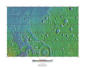
Oxia Palus quadrangle

Map of Oxia Palus quadrangle from Mars Orbiter Laser Altimeter (MOLA) data. The highest elevations are red and the lowest are blue.
|
|
| Coordinates | 15°00′N 22°30′W / 15°N 22.5°WCoordinates: 15°00′N 22°30′W / 15°N 22.5°W |
|---|---|
The Oxia Palus quadrangle is one of a series of 30 quadrangle maps of Mars used by the United States Geological Survey (USGS) Astrogeology Research Program. The Oxia Palus quadrangle is also referred to as MC-11 (Mars Chart-11).
The quadrangle covers the region of 0° to 45° west longitude and 0° to 30° north latitude on Mars. This quadrangle contains parts of many regions: Chryse Planitia, Arabia Terra, Xanthe Terra, Margaritifer Terra, Meridiani Planum and Oxia Planum.
Mars Pathfinder landed in the Oxia Palus quadrangle at 19°08′N 33°13′W / 19.13°N 33.22°W, on July 4, 1997. Crater names in Oxia Palus are a Who's Who for famous scientists. Besides Galilaei and DaVinci, some of the people who discovered the atom and radiation are honored there: Curie, Becquerel, and Rutherford.
Mawrth Vallis was strongly considered as a landing site for NASA's next Mars rover, the Mars Science Laboratory. The Mawrth Vallis region is well studied with more than 40 papers published in peer-reviewed publications. Near the Mawrth channel is a 200 meter high plateau with many exposed layers. Spectral studies have detected clay minerals that present as a sequence of layers. Clay minerals were probably deposited in the Early to Middle Noachian period. Later weathering exposed a variety of minerals such as kaolin, alunite, and jarosite. Later, volcanic material covered the region. This volcanic material would have protected any possible organic materials from radiation.
...
Wikipedia
