Oxford Township, Philadelphia
| Oxford Township | |
| Former Township | |
| Country | United States |
|---|---|
| State | Pennsylvania |
| County | Philadelphia |
| Coordinates | 40°01′24″N 75°04′47″W / 40.02333°N 75.07972°WCoordinates: 40°01′24″N 75°04′47″W / 40.02333°N 75.07972°W |
| Timezone | EST (UTC-5) |
| - summer (DST) | EDT (UTC-4) |
| Area code | 215 |
|
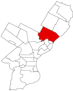
Map of Philadelphia County, Pennsylvania highlighting Lower Oxford Township prior to the Act of Consolidation, 1854
|
|
|
Location of Pennsylvania in the United States
|
|
Oxford Township was a now-defunct township in Philadelphia County, Pennsylvania. The township ceased to exist and was incorporated into the City of Philadelphia following the passage of the Act of Consolidation, 1854.
A township running from the county line in southeast direction to the Delaware River, and along the same southwest to Frankford Creek, and up the same northwestwardly to Tacony Creek (Tookany), which it followed until it reached the county line near were the northwestern boundary joined it. Frankford, Whitehall, Cedar Grove and Volunteer Town were in this township, and it also took in the former township of Tacony. Greatest length, 3 miles; greatest breadth, 4 miles; area, 7,680 acres (31 km²). It was one of the earliest townships established in Pennsylvania. The township was surrounded by the waters of the Delaware and Frankford Creek on two sides, and was traversed by the Little Tacony and Sissamocksink (Wissinoming) or Little Wahauk Creeks.
...
Wikipedia


