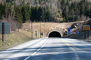
Oslofjord Tunnel

Hurum entrance
|
|
| Overview | |
|---|---|
| Location | Oslofjord |
| Route |
National Road 23 |
| Start | Måna, Frogn |
| End | Verpen, Hurum |
| Operation | |
| Work begun | 14 April 1997 |
| Opened | 29 June 2000 |
| Owner | Norwegian Public Roads Administration |
| Vehicles per day | 6,827 (2012) |
| Technical | |
| Length | 7.306 km (4.540 mi) |
| No. of lanes | 3 |
| Operating speed | 70 km/h (43 mph) |
| Lowest elevation | −134 m (−440 ft) |
| Width | 11.5 m (38 ft) |
| Grade | 7% |
Coordinates: 59°39′53″N 10°36′47″E / 59.66472°N 10.61306°E
The Oslofjord Tunnel (Norwegian: Oslofjordtunnelen) is a subsea road tunnel which traverses the Oslofjord, connecting Hurum and Frogn in Norway. Carrying three lanes National Road 23, the 7,306-meter (23,970 ft) long tunnel reaches a depth of 134 meters (440 ft) below mean sea level. The tunnel has a maximum gradient of seven percent. It acts as the main link connecting Buskerud with Follo and Østfold, supplementing the Moss–Horten Ferry which runs further south.
The crossing was originally served by the Drøbak–Storsand Ferry, which commenced in 1939. Plans for a fixed link were launched in 1963, originally based on two bridges which would connect to Håøya. Plans resurfaced in the early 1980s with the advent of subsea tunneling technology and the Oslo Airport location controversy, which proposed airports in Hurum, Ås and Hobøl. Even though Gardermoen was ultimately build as the airport, the tunnel had raised sufficient support to be built irrespectively. Parliament gave approval on 13 December 1996 and construction started on 14 April 1997. The tunnel was official opened on 29 June 2000 and was financed in part by a toll, collected by Bompengeselskapet Oslofjordtunnelen at a toll plaza in Frogn. In 2014, the manual toll station was replaced by an automatic station. Since 30 August 2016, it is free to pass through the tunnel.
...
Wikipedia
