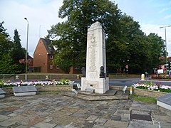
Orpington, England
| Orpington | |
|---|---|
 The Orpington War Memorial which stands in Orpington High Street |
|
| Orpington shown within Greater London | |
| Population | 15,311 (Orpington ward 2011) |
| OS grid reference | TQ460660 |
| • Charing Cross | 13.4 mi (21.6 km) NW |
| London borough | |
| Ceremonial county | Greater London |
| Region | |
| Country | England |
| Sovereign state | United Kingdom |
| Post town | ORPINGTON |
| Postcode district | BR5, BR6 |
| Dialling code | 01689 |
| Police | Metropolitan |
| Fire | London |
| Ambulance | London |
| EU Parliament | London |
| UK Parliament | |
| London Assembly | |
Orpington is a town and electoral ward in the London Borough of Bromley in Greater London and lies at the south-eastern edge of London's urban sprawl. It is identified in the London Plan as one of 35 major centres in Greater London. Before the creation of Greater London in 1965 Orpington was in the county of Kent. Kent remained the postal county for Orpington after this time.
Stone Age tools have been found in several areas of Orpington, including Goddington Park, Priory Gardens, the Ramsden estate, and Poverest. Early Bronze Age pottery fragments have been found in the Park Avenue area. During the building of Ramsden Boys School in 1956, the remains of an Iron Age farmstead were excavated. The area was occupied in Roman times, as shown by Crofton Roman Villa and the Roman bath-house at Fordcroft. During the Anglo-Saxon period, Fordcroft Anglo-Saxon cemetery was used in the area. The first record of the name Orpington occurs in 1038, when King Cnut's treasurer Eadsy gave land at "Orpedingetune" to the Monastery of Christ Church at Canterbury. The parish church also pre-dates the Domesday Book. On 22 July 1573, Queen Elizabeth I was entertained at Bark Hart (Orpington Priory) and her horses stabled at the Anchor and Hope Inn (Orpington High Street). On the southern edge of Orpington, Green St Green is recorded as 'Grenstretre', which means a road covered with grass. It is known in the 1800s as Greenstead Green.
...
Wikipedia

