Ormesby
| Ormesby | |
|---|---|
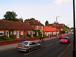
 Ormesby High Street |
|
| Population | 5,942 (2011.ward) |
| OS grid reference | NZ534166 |
| Unitary authority | |
| Ceremonial county | |
| Region | |
| Country | England |
| Sovereign state | United Kingdom |
| Post town | MIDDLESBROUGH |
| Postcode district | TS7 and TS3 |
| Dialling code | 01642 |
| Police | Cleveland |
| Fire | Cleveland |
| Ambulance | North East |
| EU Parliament | North East England |
| UK Parliament | |
Ormesby is a former village, and now suburb, spanning the Middlesbrough and Redcar and Cleveland unitary authorities in north-east England, within the ceremonial county of North Yorkshire. It forms part of the Middlesbrough agglomeration subdivision of Teesside. It has a population of approximately 6,500 residents measured at 5942 at the 2011 census.
A surviving remnant of the original Ormesby village is the High Street's 18th century Sundial Row, a terrace of ex-almshouses and stables which are now private houses. Alongside the almshouses is a betting shop which was once a school: it bears the inscription,
These buildings, together with the Grade I listed National Trust property, Ormesby Hall form the centrepieces to a conservation area.
Ormesby manor and church are recorded in the Domesday Book as the property of 'Orme', to whose name the suffix 'by' (the Viking word for habitation or dwelling place) was added to make Ormesby.
The manor of Ormesby was extensive and stretched about 4 miles (6.4 km) from the banks of the River Tees to the brow of the hill south of Ormesby village. Its east and west boundaries were defined by the becks, Spencer Beck and Ormesby Beck, – beck being the north of England word for stream. A third beck, the aptly named Middle Beck, ran parallel to the others, through the middle of the village, along Church Lane, dividing the manor into two strips of land of roughly the same size.
The village itself was probably centred on Church Lane, being part of the ancient road that linked the River Tees to Guisborough and Stokesley.
In medieval times, a substantial part of the manor was granted to Gisborough Priory. At this time, a grange, also known as a 'priory farm', was established in the general location of the existing Grange Farm and Ormesby Hall. It is possible, therefore, that the grange farmhouse may have occupied the site of the 17th-century house built by the Pennymans and now incorporated into the present Ormesby Hall. The records from Gisborough Priory suggest that the grange was accompanied by a settlement consisting of two rows of properties facing each other across Church Lane.
...
Wikipedia
