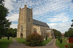
Orford, Suffolk
| Orford | |
|---|---|
 St Bartholomew's Church |
|
| Orford shown within Suffolk | |
| Population | 713 (2011 Census) |
| OS grid reference | TM422499 |
| District | |
| Shire county | |
| Region | |
| Country | England |
| Sovereign state | United Kingdom |
| Post town | WOODBRIDGE |
| Postcode district | IP12 2 |
| Dialling code | 01394 |
| Police | Suffolk |
| Fire | Suffolk |
| Ambulance | East of England |
| EU Parliament | East of England |
| UK Parliament | |
Orford is a small town in Suffolk, England, within the Suffolk Coast and Heaths AONB.
Like many Suffolk coastal towns it was of some importance as a port and fishing village in the Middle Ages. It still has a fine mediaeval castle, built to dominate the River Ore and a Grade I listed parish church, St Bartholomew's.
The main geographical feature of the area is Orford Ness, a long, wide shingle spit at the mouth of the Ore. Orford Ness has in the past been used as an airstrip testing facility and in the early 1970s it was the site of a powerful radar station as part of the Cold War defences against low-flying attacking aircraft; today it is a nature reserve run by the National Trust.
Orford provides the only point of access to the nature reserves of Orford Ness and Havergate Island. Both sites can only be accessed via ferry boat from Orford quay. The Orford Ness ferry runs on selected days between April and October and the Havergate Island ferry on selected Saturdays.
The population of Orford greatly increases during the summer months due to its flourishing sailing club. As well as the Castle, Orford's attractions include river cruises, three pubs, a traditional post office which sells fresh bread, a traditional bakery, a smokehouse and a restaurant; the Butley-Orford Oysterage.
Orford forms part of the electoral ward called Orford and Tunstall. The population of this ward at the 2011 census was 1,830.
...
Wikipedia

