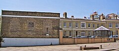
Ordnance Survey buildings, Southampton
| Ordnance Survey buildings | |
|---|---|

The former Ordnance Survey buildings in 2005
|
|
|
Location within Southampton
|
|
| Former names | Royal Military Asylum |
| General information | |
| Type | Yellow brick |
| Location | Southampton, England |
| Address | London Road |
| Coordinates | 50°54′47″N 1°24′12″W / 50.9131°N 1.4032°W |
| Construction started | 1866–1872 |
| Owner | HM Courts Service |
| Design and construction | |
| Architect | Major General Sir Henry James |
The former offices of Ordnance Survey are situated in London Road, Southampton, close to the junction with The Avenue, and are now part of the city's court complex and are occupied by Government agencies. The buildings are Grade II listed.
Ordnance Survey originally came to Southampton on 12 November 1841, a fortnight after a fire had destroyed its headquarters in the Tower of London. It took over vacant buildings that had been built between 1794 and 1806 as barracks for the Duke of York's Royal Military School, before being used between 1816 and 1840 as a branch of the Chelsea based Royal Military Asylum. Some of the early barracks buildings had been designed by local architect, John Plaw, who also designed houses in nearby Brunswick Place.
The asylum, which gave its name to Asylum Green, the open space in the middle of The Avenue, provided schooling for up to 400 military orphans and children of serving soldiers of both sexes until 1823, when the boys were transferred to Chelsea, with Southampton taking more girls. A decline in the school numbers resulted in its closure in 1840.
Although originally reluctant to move to Southampton, Ordnance Survey soon settled in the town and over the next sixty years, several new buildings were erected, with most of the original asylum and barracks buildings being demolished. The main building, erected in the 1850s, featured a clock tower that became a prominent landmark in the town.
In 1940, the buildings were seriously damaged in the Blitz as a result of which Ordnance Survey moved much of its activities to temporary buildings at sites in Chessington in Surrey and by Crabwood House in Maybush, on the outskirts of Southampton. By May 1969, the vast majority of staff had moved to the new, 'permanent', purpose-built headquarters complex in Maybush; when Ordnance Survey vacated the London Road site.
Most of the late-Victorian buildings have now been cleared away, along with 20th-century buildings such as the printing building. Most of the remaining buildings are occupied by various Government agencies in conjunction with the modern court complex built on the northern part of the site, including the Crown Prosecution Service, and previously by the Official Receiver (who is now based in Commercial Road).
...
Wikipedia

