Opuwo
| Opuwo | |
|---|---|

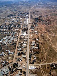
aerial view of Opuwo
|
|
| Location in Namibia | |
| Coordinates: 18°3′20″S 13°50′26″E / 18.05556°S 13.84056°ECoordinates: 18°3′20″S 13°50′26″E / 18.05556°S 13.84056°E | |
| Country |
|
| Region | Kunene Region |
| Constituency | Opuwo |
| Government | |
| • Mayor | Pieter de Villiers |
| Population (2011) | |
| • Total | 7,657 |
| Time zone | West Africa Time (UTC+1) |
| Climate | BWh |
Opuwo is the capital of the Kunene Region in north-western Namibia. The town is situated about 720 km north-northwest from the capital Windhoek, and has a population of c. 7,500. Pieter de Villiers of the Congress of Democrats is the town's mayor.
The name Opuwo was given by the commissioner of Ondangwa, Mr. Hugo Hahn, who came in search of land to build an office. Upon his arrival, he asked local headmen to give him land where he could build an office. The headmen gave him a small plot, and when the headmen tried to give him more land, Mr. Hahn responded saying "Opuwo (it’s enough for me). I don’t want any more land". That is how Opuwo got its name. The local residents of Opuwo called it Otjihinamaparero at the time, and some still call it that.
Hugo Hahn called the land “Ohopoho Otjitopora” which means "they see the bore hole and their water comes out". The name Otjihinamaparero was changed to Opuwo in 1974 due to orthographic reform.
The first office to be established in the Kaokoland area was the colonial administrator in Swartbooisdrift on the banks of the Kunene River. This was the administrative centre of the area from 1925 to 1939. Afterwards, administrative control of the area shifted to Ohopoho, later called Opuwo.
The police station in Swartbooisdrift was run by Sergeant Herbert, and his aim was to receive the Angola Boers who had trekked to Angola out of refusal to accept the British government in South Africa. Sergeant Basson took over the office at Swartbooisdrift, and excavated Opuwo's first bore hole. Basson had the nickname “Katjiriamakaja” (a person who eats tobacco).
Opuwo is situated at the intersection of the C41 and C43. There is a small airfield in town, Opuwo Airport.
Putuavanga Senior Secondary School in town is among the best government schools in Kunene Region. There is also the Opuwo Primary School with[update] 39 teachers and 1,200 learners.
...
Wikipedia

